What do you trust more new charts or permanent buoys?

Alex F

Well-Known Member
Nov 14, 2006
9,166
Miami / Ft Lauderdale
Boat Info
2005 420DB with AB 11 DLX Tender, Raymarine Electronics (2x12" MFDs) with Vesper AIS
Engines
Cummins 450Cs, 9KW Onan Generator, 40HP Yamaha for tender.
My boat has two different Raymarine displays. One uses Navionics charts and the other uses C-Map charts. At the beginning of the season I bought updated charts and had no issues.

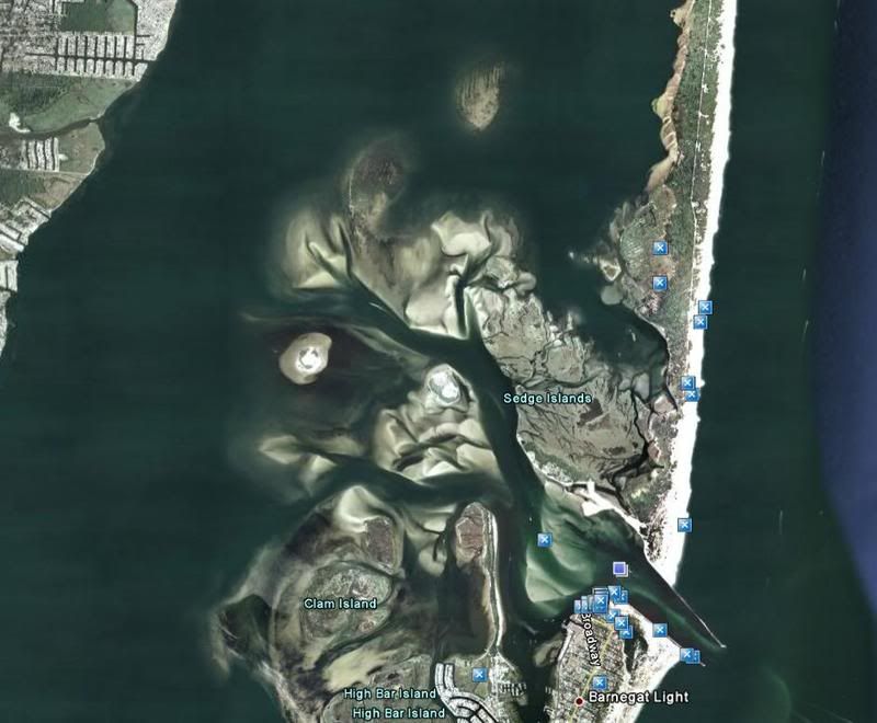
There was one strange thing that happened to me when I was coming back from Atlantic City trip last summer. After I entered Barnegat Inlet, at the end of the Oyster creek there’s a sharp turn to the starboard around the ICW buoy. The issue was that I was following my plotter very closely but the buoy was couple hundred feet off course. I had enough depth, but I was very surprised how much off the buoy was from the chart. This buoy looks like it's there permanently, b/c it’s on large pilings. So, it’s not like coast guard would move it every month or so.

Dominic, you know this area like back of your palm. Any thoughts on this one?

Also folks, what do you do in general when facing situations like this, would you trust and follow your Chartplotter with updated cards or would you go for the buoy (permanent, not floating)?

Thanks,
Alex.
 
I think local knowledge wins, I'd try to find me some of that first. If that wasn't available I'd put more faith in the buoy than the printed chart.
 
I never follow the electronic chart. I've found mine lacks in the accuracy necessary to do that. By the description of your situation I would go by the buoy.
 
I'd also go by what your eyes are seeing. Read the water, read the buoys, then read the chart.

Doug
 
eyes win with permanent bouys for me. Floating bouys on the other hand seem to move around a lot in the sound. maybe barges hit and drag them, who knows.
 
Buoys Move - markers on pilings shouldn't. If you head East in the ICW from Panama City, Fl toward Apalachicola, on the East end of East Bay, there is an area where you turn right from Northeast to Soutneast. The charts and chartplotter show this as a narrow channel. The buoy to stbd that marks the inside edge of the turn is 100 yards to the SE of the channel. Don't cut the buoy close. Actually, you can't. You won't even get close to it.

http://maps.google.com/maps?f=q&sou...513,-85.429988&spn=0.025632,0.038452&t=h&z=15

Give the link a second to build - you can see the channel.
 
I agree with permanent markers, and I would even trust buoys before charts. The ultimate tool that will override both of those is my depth finder though. Whenever I am wondering about where to go, I keep a really close eye on what the bottom is doing.
 
Alex:

You are talking about the Oyster Creek Channel heading to/from the Barnegat Inlet.

The ICW 'dolphin' marker at that point is the "BI" (Barnegat Inlet) marker. If it was marked by number it would be 'ICW 42'. The Dolphin just north is the "BB" (Barnegat Bay) marker and if it was numbered it would be 'ICW 41'.

Here's a pic of the 'BI' marker...
ICWmarkerBI.jpg


When you are heading west, returning from the ocean and following the Oyster creek Channel, you will be following floating Nuns and Cans. They are NOT ICW markers. My memory fails me, but I'm pretty sure that the west most floating Nun is marker number 40...again...not ICW.

The Oyster Creek channel changes regualarly....so much so that NO chart, no matter how current it is, will have the markers correct. You have to read the NTM to get the most up to date info on the placement of those markers. You can get an idea of the shoaling from the pic below....
BarnegatInlet1.jpg


Anyway, getting back to your question, the "BI" Dolphin permanent ICW marker, to the best of my knowledge, has not been moved in many, many years....possibly never.

The last Oyster Creek Channel (red nun '40') is not an ICW marker. Keep it to your stbd when returning from the Ocean.

The BB and BI markers are white/orange Center Channel Markers and they can be passed either side-to.

As an aside, you can always tell an ICW marker from other non ICW markers by the gold/yellow square or triangle. A lot of folks run aground swearing they were in the channel only tofind out later that they left the ICW and were between channels.

The ICW in the Barnegat Bay area, up until the late 80's, with the exception of the BI and BB markers was ALL floating cans and nuns and they did 'drift' from time to time. In the late 80's the gov'ment replaced them with the permanent dolphin markers.
 
Last edited:
While I like the paper charts and my new chartplotter - I have to rely on markers in my area. Things change way too much - especially in Oregon Inlet - and probably almost any inlet due to the tides and such.
 
It looks like most of you would trust permanent buoy over the updated chartplotter cards. My only concern is that channels do shift due to some weather fronts. So, I would imagine that this is a big task for CG to move some heavy duty buoy structure and it would take sometime (may be couple of moths) to do it. This was the reason I had more faith in my charts. On the other hand I thought that floating buoys are placed due to constant surface shifting, so they could be moved accordingly in timely manner. A good example I had on the same trip. On the way to AC I was in the Little Egg Harbor. I wanted to take a ride to a spot to take my crew for a swim. There was a channel well marked by floating buoys and I was watching closely my chartplotters and depthfinder since I have limited knowledge for the area. I followed marked channel and both charts were showing that I had 15-20’ depth just off the channel. So, at idle speed I started making my way to the “deep” area out of the channel so we can drop the anchor and chill. A moment later, around 50-100’ my depthfinder shows 2-3’ of water while both plotters show that I should have 15-20’. I was surprised, but following the same theory, the channel was marked by floating buoys, so I understand that they were moved as soon the bottom conditions had changed. Thus, I was thinking that it’s better to trust floating buoys vs. the charts for that same reason. On the other hand this is very different from permanent buoys, so if conditions do change and they don’t change the buoys position this might be an issue. I guess, the other good argument is that charts that are purchased in spring time most likely were made few months back, thus in the mid July I’m looking at the 4+ month old charts. However, the bottom line question is, if the permanent buoys don’t get moved wouldn’t even 4 months old chart show more accurate data?

Thanks,
Alex.
 
The gov'ment is 'supposed' to maintain the ICW channel. Many here along the East coast ICW can attest to that NOT being necessarily so.

usually when the area around the permanent dolphins shoals to a point of it being a hazard to mariners, or if the marker gets hit, the CG will place temporary floating ICW markers. There are a few around 162 and 164. There's also one up in your area Alex....around 25 or so. When ever I come to an area where you see both a dolphin and floating marker, I travel the floater...so long as I see the gold maker.
 
You can't just make a blanket statement: "Follow the permanent bouys", because even the huge metal bouys do get off station from time to time. I don't know about in the NJ area, but on the Gulf coast, the storms will cause some bouys to move every year. They will slide with the wind until the water is shallow enough to increase the scope on the chain holding them. I've seen then as much as a mile off station after a particularly bad blow with a surge.

The Coast Gurad usually doesn't just randomly place bouys, so looking at a chart with bottom countours on it will usually help answer your question as to where a bouy should be. If in doubt, local knowledge is king, so follow Jim's suggestion and get to Sea Tow, TowBoat/US, local water cops, a local fisherman, etc. via VHF and ask.

On the question about relocating off station bouys, the CG usually does this but it takes a bouy tender. The one in our area is located in Mobile AL, so, unless they just happen to be close by, it sometimes takes several weeks for them to make their way to us since we are on the eastern edge of that tenders coverage area.


USCG local notices to mariners is also valuable since any bouy reported off station will be shown in the local notices:

http://www.navcen.uscg.gov/lnm/default.htm

Select your region, the date of the notice you want and then wait.......these are huge PDF files and it takes a while to download them. We always look at the local notices before taking a trip.
 
The only "permanent" ICW markers around here are the dolphins....three big pillings driven into the muck. They don't move unless they are rammed by a boat. Even then, the boat usually loses.

All of the floating buoys (cans and nuns) in the bay move with storms over time. The HUGE cans/nuns in the Ocean and in the Ocen inlets will also move...especially with a severe storm.
 
The Coast Gurad usually doesn't just randomly place bouys, so looking at a chart with bottom countours on it will usually help answer your question as to where a bouy should be. If in doubt, local knowledge is king, so follow Jim's suggestion and get to Sea Tow, TowBoat/US, local water cops, a local fisherman, etc. via VHF and ask.


USCG local notices to mariners is also valuable since any bouy reported off station will be shown in the local notices:

http://www.navcen.uscg.gov/lnm/default.htm

Select your region, the date of the notice you want and then wait.......these are huge PDF files and it takes a while to download them. We always look at the local notices before taking a trip.

Thanks Frank, I have never seen those local notices before. Appreciate you putting up that link. Now I will be looking at it weekly.
 
Dominic,
Thanks for detailed info on that ICW buoy. I remember the floating nuns and cans, which I was following. BTW, I think the inlet and OC channel was very well marked. I’ll pay closer attention and examine the area closer next season.

Frank,
Thanks for very useful link, this is great stuff. The funniest thing is that NJ area on the Navigation Center home page is blank. They have some info on Northeast Atlantic, but I hope all of the NJ area will be available soon.

Thanks a lot guys, keep your comments coming. This is good topic many skippers can share and learn from.
 
Electronic charts are amazing and when combined with new GPS electronics, getting from A to B has become a snap for everyone. BUT, the trouble with such sophisticated technology is we can become so used to it we forget to use our more basic skills and tools, or worse we never acquire them and are totally reliant upon gadgets.

Q: Who here has on board the following: Parallel Ruler, plot triangles, a Geometry or Chart Divider W & W/o pencil lead, and compass course protractor plus the ever handy hand bearing compass? Raise those hands high so I can see you in the back there! If your lips just went squiggly and all as you said what are those for? Then you might should consider a quick coastal navigation course which will include understanding all the "Collision Avoidance regulations and the differences between ocean bouyage and that used in the ICW and Inland waters.

I never leave my local knowledge waters without a paper chart for the area at the helm, Binoculars (with internal compass for bearings) to read marker signs and a few navigation tools. (I keep all this in a small canvas bag at my feet as Sea Ray leaves little possible space to store such things at the helm.)

If my electronic chart & GPS I'm at X and the bouy's tell me different, I recheck the bouy for relevant bouyage rules making sure I seeing the correct bouy, and if I’m still uncertain I kill the throttles and take a set of magnetic bearings from known positions on shore and verify my POS on the paper chart. If the bouy is the correct bouy and I'm where I should be, I use my pen and paper verified position to nav by. As Frank said earlier bouys drag, they get moved due to new shoaling, new ones get dropped to mark recent wrecks, Ancient ones get moved to the correct charted position based upon modern GPS positioning. What I do not due is proceed into a situation that I can not be sure I'm going to have good water under my keel. If there is a shore side source I can radio like a gas dock for some local intel, the tow boats will generally respond to sincere requests). I try to eliminate doubt by obtaining two or better three sources of confirmed position before I plow headlong into the unknown. Old school tools and skills are a real comfort to have at hand.

GPS can vary as much as 500 ft due to military dithering and combined with old chart datum and a 1000 foot variance is conceivable so a hand bearing compass and a recent paper chart can give a skipper the confidence to proceed where technology seems to be misleading him.


GPS can vary as much as 500 ft due to military dithering


I thought the Military dithering was a thing of the past. Wasn't it removed about 10+- years ago???

Don't have a place for a plotting table, but do have charts and plotting tools on board when out of my local area.
 
When the Russians put up their answer to GPS which I believe is called GLOPASS, the US military said they would not dither the signal other than for National Security purposes. When they were dithering, the standard accuracy was 500 ft radius, 1000 ft diameter "cocked hat" . The prior to the GLOPASS system going on line the US placed low power radio transmitters known as WAAS (Wide Area Augmentation System) at marine ports of entry that marine GPS units could decode and adjusted the timing dither from the military and reduced the accuracy to then 50 ft radii.

Those systems still exist and as far as I know the marine GPS units internally equipped still use the WAAS system. However, the US military has stated they no longer dither the satellite timing signals during peace time allowing accuracies down to some 5ft with the local WAAS radio adjustment. All that said, with Defcon 5, you can bet your sweet book hook the dithering will switched back on as we take out the GLOPASS sats.

New GPS antennas such as the RayStar 125 have the WAAS antenna and receiver built into the “Puck” and transmit a adjusted signal to the chart plotter so a separate antenna and receiver in the NEMA network is no longer needed.

But dithering is still alive and WAAS is working its little heart out for you every time you switch on the magic box!
 
All that said, with Defcon 5, you can bet your sweet book hook the dithering will switched back on as we take out the GLOPASS sats.

Good point. I assume you mean DEFCON 1(Grin)
 

Forum statistics

Threads
113,171
Messages
1,427,823
Members
61,082
Latest member
wavespestcontrol
Back
Top