Russ Calasant
Active Member
The 8th at Coecles is perfect, I have never been in there but I am told its fantastic, I would like to check it out.
Follow along with the video below to see how to install our site as a web app on your home screen.

Note: This feature currently requires accessing the site using the built-in Safari browser.
The 8th at Coecles is perfect, I have never been in there but I am told its fantastic, I would like to check it out.
Brian,
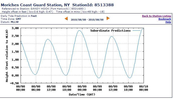
I just checked tides predictions info on http://tidesandcurrents.noaa.gov/no...erval=highlow&format=Submit&Stationid=8513388
Date Day Time Pred High/Low
2010/08/08 Sun 05:44 0.04 L
2010/08/08 Sun 10:31 2.28 H
2010/08/08 Sun 17:43 -0.01 L
2010/08/08 Sun 22:48 2.84 H
If I read it correctly, 10:31am is a good time. As I recall, you had advised to enter the Moriches Bay 20 min after. So, travelling Moriches at around 11am-11:30am could be perfect time for me. Why do we have different data on tide schedule, are we using different source?
Another question, if let's say we're not making the high tide I plan on just going very slow through troubled areas by buoy 24-29 and buoy 34 this way I can adjust the course fast if I see very shallow depths. Can I use the slow speed as a plan B to compansate or the depths are really low (I just need 2' at idle speed).
Ahhhh, just figured it out. Your looking at GMT not LDT.....gotta use LDT. And, no, I would not suggest going through Moriches at anything other than high tide + one hour after the flood tide.
Now Im confused!
Yeah, I saw the different time zone parameter in URL as you were posting. Thanks for clarification. I'm looking at 8/7 (the day we travel thru Moriches to Westhampton) and it looks just as bad. Now you got me scratching my head :smt101
Since you're coming from NJ and stopping for lunch on FI, I'd aim for the second high tide of the day. On the 7th that is 1752, though you could go through at 1700 and probably be safe. Westhampton Beach is one bridge opening and 10 minutes east of the last buoy in Moriches Bay.
About what, Russ?
I dont have any charts or anything to reference here but coming from the East, going to Westhampton, do I need to be concerned with the tide? Or just when I am leaving WH and headind to FI and Atlantique?
Brings up a couple other questions, what nav program are you using on your cmputer and wher do I get it? and, does anyone know can/should reservations be made at Westhampton or is it first come/serve?
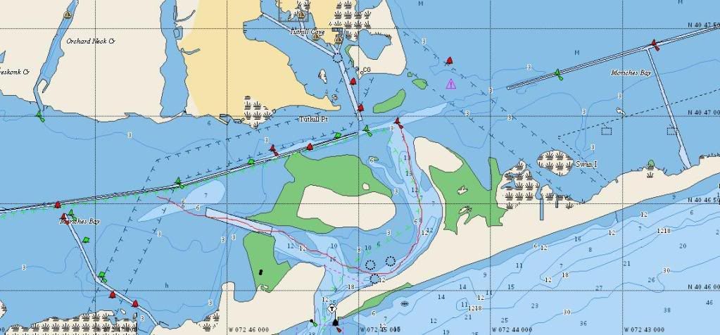
Is this the spot the guy was describing (sorry for the shaky pencil drawing, I'm on the laptop)? The way I understood his story is that it's not safe to follow the chart in this leg of the trip and the detour was the savier. Am I reading this correctly?
You have it right Russ, Moriches Bay is west of Westhampton Beach, so you need to be concerned with the tide leaving WHB and on the way back before WHB. Reservations can and should be made for WHB.
I dont have any charts or anything to reference here but coming from the East, going to Westhampton, do I need to be concerned with the tide? Or just when I am leaving WH and headind to FI and Atlantique?
Brings up a couple other questions, what nav program are you using on your cmputer and wher do I get it? and, does anyone know can/should reservations be made at Westhampton or is it first come/serve?
BMAC has the correct route from last year. I think this area us undergoing a dredging project so it's best to wait for the route. Frank from WHB town dock always has the latest bouy information and he has been the most reliable source.
