Hmmm - my radar is skewed 6 degrees from the chart on one screen but matches the chart orientation on the other. I'll go and look again at the settings.This sounds right. I had a bunch of settings dialed in on my 8616 for radar, charts, and combo screens. When I added an 8612 I didn't find a way to send them to the new unit. I had to do through and make manual changes to get them to match up. That included setting-level heading preferences. Until I got that dialed in, the two screens were showing very different heading behaviors.
Navigation
Install the app
How to install the app on iOS
Follow along with the video below to see how to install our site as a web app on your home screen.

Note: This feature currently requires accessing the site using the built-in Safari browser.
More options
You are using an out of date browser. It may not display this or other websites correctly.
You should upgrade or use an alternative browser.
You should upgrade or use an alternative browser.
Garmin GPSMap - Custom settings reset after reboot
- Thread starter Irie308
- Start date
Which is best? AP or GPS?I had to do that with the heading sensor. One screen was set to the AP heading sensor and the other was set to any. Was driving me crazy. I also wish the heading line was set the same on all screens.
So help me understand this - I'll set a waypoint, let's say 0052 and I save that waypoint. Tap on the screen then tap on the Waypoint menu item then save/rename. Now 0052 is in the waypoint menu/list for future use.With Garmin Waypoint labels are managed in two spots, one is for all instances and the other is for that session. Meaning while underway you can turn off tracks and labels until the power cycles. And you can dig into the settings and turn them off until you re-enable them.
Now if I want to bring it up and set a course to it, I can either go to the list or tap on it on the screen.
Where else are the waypoints stored?
Skybolt
Well-Known Member
- Nov 11, 2014
- 6,469
- Boat Info
- Reel Nauti
460 EC
- Engines
- Detroit 6v92TA
(Low profile's)
Alison Gears
Westerbeke
12.5kw Genset
Which is best? AP or GPS?
I use the AP heading sensor as that is what the boat is being steered by. The GPS heading sensor I have is the GPS24xd. But I also calibrated that to be within one degree of the AP heading sensor. But you may have a different opinion. I tend to trust the fluxgate compass over everything else, but I am old school with that.
Skybolt
Well-Known Member
- Nov 11, 2014
- 6,469
- Boat Info
- Reel Nauti
460 EC
- Engines
- Detroit 6v92TA
(Low profile's)
Alison Gears
Westerbeke
12.5kw Genset
So help me understand this - I'll set a waypoint, let's say 0052 and I save that waypoint. Tap on the screen then tap on the Waypoint menu item then save/rename. Now 0052 is in the waypoint menu/list for future use.
Now if I want to bring it up and set a course to it, I can either go to the list or tap on it on the screen.
Where else are the waypoints stored?
In the user data, the main waypoint list is in there and there are settings to display them. That is where you can manage them. But one setting comes to mind is it will display when in view, but that can be turned off so you don't see a bunch of pins everywhere.
EDIT: I believe from any screen the bottom ribbon left has an info tag (or something), hit that and go from there.
Ok so there is only One list of waypoints... For some reason I thought you were alluding to more than one.In the user data, the main waypoint list is in there and there are settings to display them. That is where you can manage them. But one setting comes to mind is it will display when in view, but that can be turned off so you don't see a bunch of pins everywhere.
EDIT: I believe from any screen the bottom ribbon left has an info tag (or something), hit that and go from there.
Tripsdad
Well-Known Member
I’ve been using my Garmins (8612 and 942) for 4 seasons now and set up some custom split screens but didn’t know about the pre-sets. Always learn something new here. Thanks guys!
That was my problem too. One was using the heading sensor and one was using GPS COG for heading. Made the boat look like it was crabbing sideways and 30 degrees off. Took a lot of digging to figure it out. And each screen needed some configuration. I like Garmin but that was a real PITA.I had to do that with the heading sensor. One screen was set to the AP heading sensor and the other was set to any. Was driving me crazy. I also wish the heading line was set the same on all screens.
Oh, and on the chart screens you can set a lead line for both Heading and GPS COG. This is surprising use for to see your cross track error. And which way the boat is pointed.
Skybolt
Well-Known Member
- Nov 11, 2014
- 6,469
- Boat Info
- Reel Nauti
460 EC
- Engines
- Detroit 6v92TA
(Low profile's)
Alison Gears
Westerbeke
12.5kw Genset
Ok so there is only One list of waypoints... For some reason I thought you were alluding to more than one.
Right one list, but two different place or ways with settings. One affects the current powered on session and the other withstands a power cycle.
Skybolt
Well-Known Member
- Nov 11, 2014
- 6,469
- Boat Info
- Reel Nauti
460 EC
- Engines
- Detroit 6v92TA
(Low profile's)
Alison Gears
Westerbeke
12.5kw Genset
That was my problem too. One was using the heading sensor and one was using GPS COG for heading. Made the boat look like it was crabbing sideways and 30 degrees off. Took a lot of digging to figure it out. And each screen needed some configuration. I like Garmin but that was a real PITA.
Oh, and on the chart screens you can set a lead line for both Heading and GPS COG. This is surprising use for to see your cross track error. And which way the boat is pointed.
I had that happen on a recent trip. Drove me crazy, to the point I thought my AP heading sensor died. I ended up re-calibrating the AP and GPS heading sensors and they both passed and the screen was still not right. Like you, it took a while to dig through all of the settings and fix it. In the end it was quite simple, but their documentation doesn't cover the use cases for finding the right settings. A real PITA to figure out for sure.
Irie308
Well-Known Member
- May 28, 2013
- 2,599
- Boat Info
- 2004 420 DB, GHS Hydraulic Lift
Garmin 8600/Garmin 1222 plus
AB Mares 10 VSX with 30 hp Tohatsu
- Engines
- Cummins 450C 8.3 L Turbocharged
Never calling Garmin again. Will check with this group first. Can’t believe they didn’t point me in this direction. Problem solved!
I'm all Garmin also and dismayed with the poor manuals and lack of technical support. I wonder if their aircraft electronics are the same? I will say though that my Fantom radar failed well after the warrantee period and they replaced it no questions asked. But, I think there is some basic issues with the radar design as I've known of quite a few that have failed and Garmin standing up replacements.Never calling Garmin again. Will check with this group first. Can’t believe they didn’t point me in this direction. Problem solved!
If I could get a paper manual like on the MFD owner's manual I would. It seems counterintuitive to have a TS manual on the device you are trying to TS. Plus I like to read when I can sit in my office or xxx rather than sit in front of the MFD.
The paper manuals, when Garmin published them, were still kinda basic. Had a lot of info but still light in many areas. For a while they still made a PDF version of the manuals that could be downloaded and browsed.I'm all Garmin also and dismayed with the poor manuals and lack of technical support. I wonder if their aircraft electronics are the same? I will say though that my Fantom radar failed well after the warrantee period and they replaced it no questions asked. But, I think there is some basic issues with the radar design as I've known of quite a few that have failed and Garmin standing up replacements.
If I could get a paper manual like on the MFD owner's manual I would. It seems counterintuitive to have a TS manual on the device you are trying to TS. Plus I like to read when I can sit in my office or xxx rather than sit in front of the MFD.
I think they have moved to an HTML version with distinct sections. In some ways this is useful because you can go to the section you need, then link over to other related sections. For browsing and learning your gear it's not as good as a linear manual.
However, I think a modern limitation of the paper/PDF manuals is how often Garmin adds and updates features. They do a couple SW releases a year, and from my own manual review/publishing experience it's much easier to add or update a section to the online HTML manual then to have to redo a linear document. The technical documentation group where I worked always needed a long lead time to write, vet, and update the traditional manuals.
Brad, PDF's are still available but they don't make it easy. You now have to access the HTML version of the manual. There is an icon on the upper right of the screen that will bring up the PDF in a web page:The paper manuals, when Garmin published them, were still kinda basic. Had a lot of info but still light in many areas. For a while they still made a PDF version of the manuals that could be downloaded and browsed.
I think they have moved to an HTML version with distinct sections. In some ways this is useful because you can go to the section you need, then link over to other related sections. For browsing and learning your gear it's not as good as a linear manual.
However, I think a modern limitation of the paper/PDF manuals is how often Garmin adds and updates features. They do a couple SW releases a year, and from my own manual review/publishing experience it's much easier to add or update a section to the online HTML manual then to have to redo a linear document. The technical documentation group where I worked always needed a long lead time to write, vet, and update the traditional manuals.
From there, you would use whatever method your OS provides to get copy you can save. Safari has an icon on any PDF web page to quickly open it in Acrobat and save from there.
But I certainly agree Garmin does not tend to quickly update either version of the manual to reflect the latest releases. I believe it took at least a year for Garmin to document the auto-MARPA feature.
Irie308
Well-Known Member
- May 28, 2013
- 2,599
- Boat Info
- 2004 420 DB, GHS Hydraulic Lift
Garmin 8600/Garmin 1222 plus
AB Mares 10 VSX with 30 hp Tohatsu
- Engines
- Cummins 450C 8.3 L Turbocharged
One more question for the "Garmin Gurus". Not sure if anything can be done about it but i find that my AIS targets don't necessarily overlap the radar target. I assume there is a slight delay with the reported positioning of the ais target vs the radar detecting the actually target in Realtime. Any thoughts on this? (VESPER AIS XB-8000)
Unless the display is very close in and blown up, the positions ought to be fairly close. If the range is close but the bearing is consistently off, that may be a function of how well your heading sensor is aligned.One more question for the "Garmin Gurus". Not sure if anything can be done about it but i find that my AIS targets don't necessarily overlap the radar target. I assume there is a slight delay with the reported positioning of the ais target vs the radar detecting the actually target in Realtime. Any thoughts on this? (VESPER AIS XB-8000)
Irie308
Well-Known Member
- May 28, 2013
- 2,599
- Boat Info
- 2004 420 DB, GHS Hydraulic Lift
Garmin 8600/Garmin 1222 plus
AB Mares 10 VSX with 30 hp Tohatsu
- Engines
- Cummins 450C 8.3 L Turbocharged
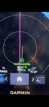
Definitely looks like bearing misalignment to me. The AIS heading looks like it's pointed right at you so radar latency would place the target on the same bearing but closer if that was it. Range looks the same for both AIS and radar target.Here’s an example. Best photo I could find.
Edit: I take it that the radar target in question is the blue blob at the same range as the AIS target and just to the left of and above "H-UP" on the screen. Different story if it's the Marpa target.
The green triangle is the AIS that is coincident with the MARPA target is what you are saying?Here’s an example. Best photo I could find.
Assuming so then check all of the devices and make sure they are using the same coordinate system and no offsets are installed.
As an edit if you are running then what Al says above would contribute.
Irie308
Well-Known Member
- May 28, 2013
- 2,599
- Boat Info
- 2004 420 DB, GHS Hydraulic Lift
Garmin 8600/Garmin 1222 plus
AB Mares 10 VSX with 30 hp Tohatsu
- Engines
- Cummins 450C 8.3 L Turbocharged
The triangle (AIS) is just right of the radar target (blue target).The green triangle is the AIS that is coincident with the MARPA target is what you are saying?
Assuming so then check all of the devices and make sure they are using the same coordinate system and no offsets are installed.
As an edit if you are running then what Al says above would contribute.