CSR Rendezvous 2009 – Atlantic City NJ

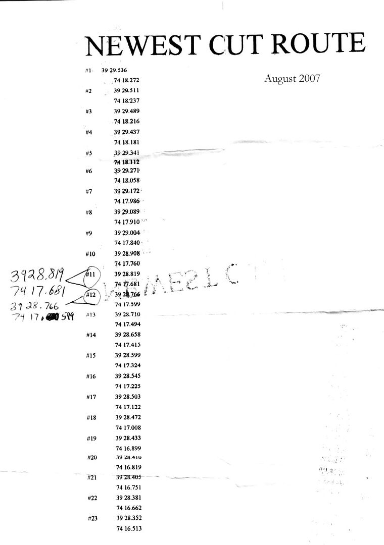
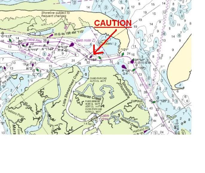
Who has a chart of the Little Egg Inlet so you can point out where everyone runs aground...do birds walk on water? Seatow hang out there too. Its about 1/2 mile before the inlet where if you missing seeing the bouy on the port side (going to AC), you are aground. No problems at low tide, but at high tide is the trap. Ed

This why we have Dom as a lead boat.

You'll be fine with updated charts, but last year I've had issue finding good depth heading out of the LEI. It wasn't marked well and depths didn't match the updated chart. But, the shallow area you're referring to are clearly shown on the chart.
 
I don't think anyone is worried about running aground in Little Egg Inlet or Beach Haven Inlet or whatever they're calling it these days. I haven't been through it this year but I did it twice last year and twice in 2007. 2007 was an adventure but in 2008 it was very well marked. This set of waypoints was given to me by a sportfisher operating a 46' Ocean Yacht out of lower LBI. He used this route hundreds of times but gave me the disclaimer that my results may vary. This route is in my plotter and correlated nicely with the way the inlet was marked last summer.


BHInlet2007Waypoints.jpg
 
Sometime in late July last year, the buoys in the LE inlet were repositioned. The previous course was more southerly and the re-positioned course takes a more northerly track as you head out to sea. The difference between the two routes on the track lines on my chartplotter is striking. I called the UCSG last weekend seeking some local knowledge on the inlet and was informed that the inlet is marked well and positioned correctly. I would be careful using the GPS points above since they are from 2007 and there has been a lot of shoaling since then
 
Mark....thanks for the local info....it's always the best info...

All:

You can see from the chart below where I point to an area of concern. It's right at ICW 116A.
LEICAUTION.jpg

I have seen many folks go aground in this area...SeaTow hangs in this area for a reason. There is another channel that crosses accross the bay there and both that channel and the ICW are marked with Floating cans/nuns so it can be confusing. USE EXTREME CAUTION. Couple that with the fact that we will be there close to the low tide and we will be very close to a full moon....so it may be even a little lower. You may even see the shoal if the tide is low enough.

When we get there, just commit to the inlet and stay in the channel. I will lead out to the ocean and then we can regroup out there.....Last year, at a high tide, I saw less then 5 feet of water cominig out of the LEI.....Hopefully the new channel marker locations took care of that....

I want to add one more note....If anywhere along the line another boat wants to get in front of you, just let him.....if it's a very slow boat, pass him when it's safe....if he can keep our pace, it's no big deal....you should never be out of site of the convoy....
 
Mark
We passed through there in early August 08, after the markers were moved,and I mean drastically moved. The old (lousey) setup took you south along the coastline. The new one, as you stated, takes you through the middle. I had my route up on the plotter but followed the marked channel and the two practically overlapped. Apparently the locals rarely used the old south marked channel and finally the Coasties gave in and used local knowledge to set up a better deeper channel.

As for shoaling, you are absolutely correct. I would use whatever channel they have set up this year b/c these things do change every winter. My route above would be a help in a pinch but by no means should supercede a marked channel.+

This was the view exiting the inlet. Note the shoal just to the north of the marker...
100_0806.jpg
 
I think this is the marker of which Dominic speaks. It is VERY confusing with the confluence of channels, no doubt. You can see the shoal east of the channel here. And this was at near high tide. Low tide that day is 12:18pm at Little Sheepshead Creek so we'll be in pretty lean water when we pass this point. It makes for a difference of almost 3' of water under your boat, which we all know is very significant on Barnegat Bay.


100_0805.jpg
 
Ron - isn't that schoal in your picture west of the channel?
 
Inter....Intra....East....West....it's all the same....:grin:
 
Mark
Damn you're good! I KNEW we were heading south but as I look at the orientation of the aft facing radar arch, this pic was shot looking over my right shoulder. So that would be facing west. If I was heading south and that marker was to my left, I'd be in trouble! SORRY 'bout that. I only wish I could make out the number on the buoy. I have the original shot on the hard drive but even there the resolution isn't good enough.
 
Last edited:
I believe that's a lit marker, and the only lit red down that way, according to chart 12316 is 116 (flashing ev 4 seconds). I think I recall shooting that pic b/c of all the problems people have reported in this vicinity (see Dom's post #764). It's a wonder I didn't run aground gawking at the shoal long enough to take a pic. I wonder who the hell was driving when I took it???
 
It's all this talk of grounding and moving shoals that makes me want to stay on team ocean. It looks like I will be there, just went for another sea-trial today, with a new starboard turbo, everything looks good.

They are cleaning and painting today, should be done tomorrow. Just in time for the weekend. :smt038
 
Greg

Glad to read that your back in business. Weather looks nice for Sat, cloudy on Sunday.
 
That's good news Greg!!! Take a ride to Belmar this weekend for the Seafood Festival....I'll be there with a bunch of boats from my neighborhood.....I hear they have great crabcakes!!!!!
 
You guys should move to Georgia for a few months to help them out with the drought.
 
no MD boys here....these are 'Jersey-cakes'.....right off the local Jersey shores...you need a toothpick, a cold beer and a good healthcare plan when you're done.....
 
Back to running around...Dom's pointer needs to be moved north a little (hate it when your pointer doesn't work - old age I guess). Somewhere around R N "114" is where the bird walk on water (looking to your starboard side - going south). Need to turn to port and look closely for the next bouy. skip one in your sighting and woops.

Going out to the ocean from LEI is well marked...it just looks counter intuitive because you see breakers on both sides of you as you head out. The old channel which more followed to coast going south is no longer marked.
 

Forum statistics

Threads
113,253
Messages
1,429,373
Members
61,133
Latest member
Willbeckett
Back
Top