Raymarine RayTech PC Software, offline chart plotting

hack4alivin

Active Member
TECHNICAL Contributor
Apr 18, 2008
2,518
Joppa, Maryland
Boat Info
320 Dancer
Engines
Twin 350 V Drives
For those of you with the Raymarine C and E series chart plotters Raymarine has free software for personal computers for off line charting, and saving of GPS data. The software is free and can be downloaded from this site: http://www.raymarine.com/ProductDetail.aspx?SITE=1&SECTION=2&PAGE=1890&PRODUCT=4265

The problem is without your local charts and a card reader/writer the software is no good to you. That’s where this little device comes in handy: http://www.raymarine.com/ProductDetail.aspx?SITE=1&SECTION=2&PAGE=714&PRODUCT=3752

This device when coupled with the Raymarine RayTech software will now show all your local chart data. Everything that is on the Navionics chip will be displayed allowing you to chart offline. The software also has the uploading and downloading tools available to save your existing GPS routes, tracks, and waypoints.

I just received mine and after several hours of playing with the software I am now able to do my entire course planning on the computer then download the routes and waypoints into the Raymarine C80. Getting used to panning and zooming is the key to plotting an effective route, but having played with the software for awhile now it is really easy to use. I have included several screen shots here for explanation of its use.

Chart_1.jpg

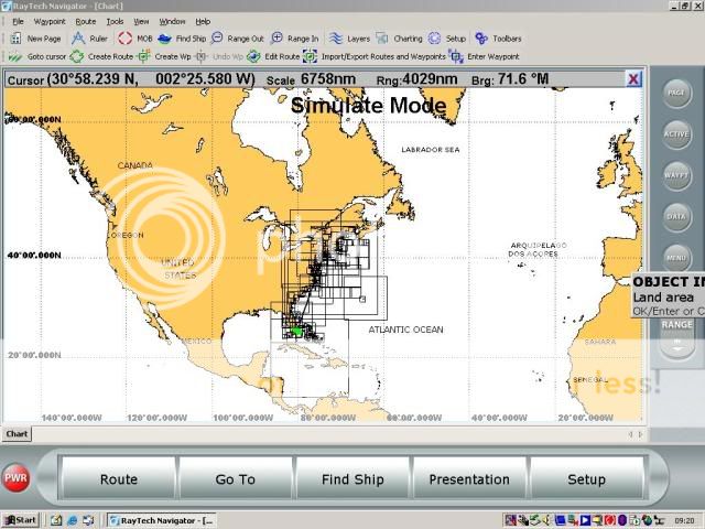
In this image we are zoomed all way to the entire east coast. All of the rectangle boxes indicate areas of chart coverage by my Navionics card

Chart_2.jpg

Here I have zoomed into the Chesepeake Bay area.

Chart_3.jpg

Now in this image I have zoomed into local waters and as you can see I have all the detail chart data from the Navionics card. Now I can use this data to plot a real course knowing locations of markers and water depths.

Moving the cursor around the map and mouse click will bring that area to the center of the screen. Then you use the zoom tool to zoom in, as I have done in the second picture. The final picture shows the detail you get from your Navionics chart when you zoom in. Here you can see where I plotted a route from the Gunpowder River to Middle River. Notice all the current buoy markers and depths are show.

If there is any interest I can keep this thread going by adding additional tips on using the software. For the $90 (reader and shipping) this is going to save me a ton of time with trip planning.
 
Last edited:
Thanks very much for sharing that Bill :thumbsup:
 
I have, for many years, used Raytech to plot my course on my personal computer. I plan trips over the winter or other time when I miss the boat. I then connect the computer to the Raymarine chartplotter via a RAYMARINE NMEA/SEATAlk conversion box and transfer routes and waypoints. Electronic charts can be obtained for free from NOAA. You download a zip file and expand it. You can get the charts as often as you like and they are updated by NOAA. This system has worked really great for me
 
Thanks Bill but one question. Which Navionics chip do you have. I was planning on getting he Gold Version for mine that covers the Central US. I had the same chip but SD format in my previous Lorance GPS.
 
Thanks Bill but one question. Which Navionics chip do you have. I was planning on getting he Gold Version for mine that covers the Central US. I had the same chip but SD format in my previous Lorance GPS.

Mine is the "Gold" version covering the Eastern US.
 
Bill

Great post, just one question.

Is that card reader propietary to raymarine? In other words, if you already have a PC card reader that can read the compact flash card do you need to buy that card?

If you need a card reader you might be able to use this from Tiger Direct. Only $9.99

http://www.tigerdirect.com/applications/SearchTools/item-details.asp?EdpNo=1951865&CatId=3479

Sabrent_CRW-EXT_main.jpg

Update, I just tried to install the Raymarine Software on Windows 7 and the installed failed. It gave me a message about installing Vista Service Pack 2. It installed on my work pc with XP without any issues.. (I just don't have a card reader on the machine)
 
Last edited:
Good question. Apparently, you need a "special" card reader...
Wonder what's "special" about it...?

>I have the Raymarine Raytech Software / Fugawi Software and would like to view my Navionics charts with this software, can I use a regular card reader?
A: The Navionics charts can be read with Raytech Software (CF format only at this time), Fugawi's Software (CF, MMC & SD format) or the NavPlanner Software (CF, MMC & SD). You MUST have a Navionics Multi-Card Reader to view the Navionics charts on these products. If you do not use the Navionics Multi-Card Reader you will not be able to view the Navionics charts on your pc & may corrupt the charting information. The Navionics NavPlanner software comes with the Navionics Multi-Card Reader & the NavPlanner CD. Separate Navionics Card-Readers may be purchased directly from Raymarine or Fugawi or through their Authorized Dealers.
 
Thanks for the fast answer! I wonder whats so special too... Sounds like a nice way to extract a little more cash from their loyal customers.
 
Good question. Apparently, you need a "special" card reader...
Wonder what's "special" about it...?

>I have the Raymarine Raytech Software / Fugawi Software and would like to view my Navionics charts with this software, can I use a regular card reader?
A: The Navionics charts can be read with Raytech Software (CF format only at this time), Fugawi's Software (CF, MMC & SD format) or the NavPlanner Software (CF, MMC & SD). You MUST have a Navionics Multi-Card Reader to view the Navionics charts on these products. If you do not use the Navionics Multi-Card Reader you will not be able to view the Navionics charts on your pc & may corrupt the charting information. The Navionics NavPlanner software comes with the Navionics Multi-Card Reader & the NavPlanner CD. Separate Navionics Card-Readers may be purchased directly from Raymarine or Fugawi or through their Authorized Dealers.

Yea, I had heard that and I was afraid of damaging my chart card so I bit the bullet and bought it. It all works together, and it does not appear to keep the chart data in memory or on disk if you do not have it connected while using the software. For what they charge for the chart cards I guess it would be just too easy if you could copy them and write it to a blank card using a standard reader.


I got to say though it sure works great, and it was worth the 75 plus shipping I paid for it.
 
I have also used Raytech for years. As was said earlier, NOAA's complete portfolio of charts are available for free and using them can obviate the need to carry your chart chip back and forth. Having said that, I do also have a chart card reader and sometimes find it very useful to compare the Navionics vector presentation to NOAA's raster which can be done using multiple chart windows within the Raytech interface. I got my card reader in the Navionics package which I believe was cheaper at that time than the identical Raymarine version. That package also contains Navionics' NavPlanner software which I find to be better at certain functions than Raytech, particularly waypoint management, so I tend to bounce between the two in practice.
 
Since my 240DA had Chartplotter that used C-Map cards I had purchased C-Map PC Planner, installed C-Map software and used it on the occasions. Now my 320DA has two units SL530, which uses C-Map charts and C70, which uses Raymarine CF charts. I've downloaded RayTech software latest version and was able to use C-Map card reader, but it only works for C-Map cards. When I put Navionics CF card it doesn't read it. So, this goes in line with what tobnpr posted that Navionics Card reader is required.
 
Since my 240DA had Chartplotter that used C-Map cards I had purchased C-Map PC Planner, installed C-Map software and used it on the occasions. Now my 320DA has two units SL530, which uses C-Map charts and C70, which uses Raymarine CF charts. I've downloaded RayTech software latest version and was able to use C-Map card reader, but it only works for C-Map cards. When I put Navionics CF card it doesn't read it. So, this goes in line with what tobnpr posted that Navionics Card reader is required.

Yea Alex, I think they do something tricky with that thing and I not willing to “hack” into it and risk screwing up my chip. I am having fun with it though; getting routes setup for the season’s cruising. I already have the trip to New York mapped out.
 
Bill, the plotter software is the exact reason I wanted to get power to my GPS while off the boat. I have the sw and the reader and wanted to see if I could get some old Cisco IOS CF flash modules that I got from work formatted in such a way that I could use it to transfer and back up my plots. I wanted to create them on the PC, use the IOS CF to transfer to the plotter, etc.
 

Forum statistics

Threads
113,186
Messages
1,428,174
Members
61,097
Latest member
Mdeluca407
Back
Top