Wanted to get some information regarding navigating Lake Wylie, specifically how far North can you go on the lake without having to worry about depth. We have been pretty far south, and all the way down Little Allison, but have not ventured as far North, we have only made it up to Daniel Stowe.
Navigation
Install the app
How to install the app on iOS
Follow along with the video below to see how to install our site as a web app on your home screen.

Note: This feature currently requires accessing the site using the built-in Safari browser.
More options
You are using an out of date browser. It may not display this or other websites correctly.
You should upgrade or use an alternative browser.
You should upgrade or use an alternative browser.
Navigating Lake Wylie
- Thread starter jrm005
- Start date

NCCamper
Member
Hi JRM,
We've been almost as far north as I485 near Belmont. It gets more shallow the further north you go, but it is still navigable, especially in boats our size.
Cheers!
John
We've been almost as far north as I485 near Belmont. It gets more shallow the further north you go, but it is still navigable, especially in boats our size.
Cheers!
John
Sandlapper
New Member
- Jul 19, 2009
- 25
- Boat Info
- 1998 - 215 Express Cruiser
2004 Tahoe
- Engines
- 5.0 EFI Mercruiser w/Alpha Drive
I agree with John. Just stay in the middle once you get to the Hy. 74 bridge. There are stumps if you get too close to the edge. The area along the Plant Allen steam plant is a nice area and you should not have any problems in that area. Have you been all the way to the dam on the south end? Enjoy the lake and your new boat.
Larry
Larry
Wanted to get some information regarding navigating Lake Wylie, specifically how far North can you go on the lake without having to worry about depth. We have been pretty far south, and all the way down Little Allison, but have not ventured as far North, we have only made it up to Daniel Stowe.
Generally speaking, once you get in to the "river channel" (the last bend you go around before you head straight north) the rule of thumb is to stay just slightly West of the center and you will be OK. Be careful once you pass under the first set of RR tracks. From there out it gets a bit dicey in some spots. I will not take my boat past Allen Steam Station if the lake is below 97. Even at that I run through a few areas that register 2-3 feet.
I took my 225WE up to the Mt.Holly-Huntersville Road (Hwy27) bridge and turned around. It is not advisable to go beyond that point as it gets very risky due to rocks. I believe Dave S took a previous boat all the way or close to the Mt. Island Lake dam once and may be able to share some tips.
I have had my 280 just past I85 and turned around at the north side of Tailrace marina. If you have a map and are going to be at the dock any time soon, I will be glad to point out the areas of caution I have observed.
Every time I go up there it seems like I see someone speed past me onthe East side after the first RR bridge then they slow WAY down and start following behind.
You mentioned you were taking the Lighthouse Service Boat Safety Course. They also offer a "Navigating Lake Wylie" class that I found very informative.
Last edited:
I agree with John. Just stay in the middle once you get to the Hy. 74 bridge. There are stumps if you get too close to the edge. The area along the Plant Allen steam plant is a nice area and you should not have any problems in that area. Have you been all the way to the dam on the south end? Enjoy the lake and your new boat.
Larry
I have not been down to the dam on the south end, we have only gone as south as the entrance to Little Allison. How much further south can we go?
Generally speaking, once you get in to the "river channel" (the last bend you go around before you head straight north) the rule of thumb is to stay just slightly West of the center and you will be OK. Be careful once you pass under the first set of RR tracks. From there out it gets a bit dicey in some spots. I will not take my boat past Allen Steam Station if the lake is below 97. Even at that I run through a few areas that register 2-3 feet.
I took my 225WE up to the Mt.Holly-Huntersville Road (Hwy27) bridge and turned around. It is not advisable to go beyond that point as it gets very risky due to rocks. I believe Dave S took a previous boat all the way or close to the Mt. Island Lake dam once and may be able to share some tips.
I have had my 280 just past I85 and turned around at the north side of Tailrace marina. If you have a map and are going to be at the dock any time soon, I will be glad to point out the areas of caution I have observed.
Every time I go up there it seems like I see someone speed past me onthe East side after the first RR bridge then they slow WAY down and start following behind.
You mentioned you were taking the Lighthouse Service Boat Safety Course. They also offer a "Navigating Lake Wylie" class that I found very informative.
We will be at LWM on Saturday morning to go out for the day. Would appreciate getting your advice on the areas. We would like to venture up North more. So no issues getting up near Tailrace?
I have not been down to the dam on the south end, we have only gone as south as the entrance to Little Allison. How much further south can we go?
You can go all the way to the dam on the south end with no problem. The "dam" references here have been talkign about the dam to the north- Mt. Island Lake Dam
We will be at LWM on Saturday morning to go out for the day. Would appreciate getting your advice on the areas. We would like to venture up North more. So no issues getting up near Tailrace?
OK, maybe we can catch up. Once I figure out if I will be there Sat morning I will PM you.
I will not take my boat past Allen Steam station when the lake is below 97. Today the lake is exactly 97. Keep in mind though I have more draft and weight to worry about than you do plus I am a pretty cautious boater.
Being as you have no experience up on the north end, I would recommend you not go too far yet if the level drops much below 97. Once you find your away around you could probably go down to 96 and be OK. As I said there are still some 2-3 foot areas with the lake at 97.
It really is a neat adventure. I don't go up there much anymore because I can't pull my boat off by hand if I run up on a mud shoal and it costs too darn much in gas. But I think you will have a lot of fun. I would advise you to visit West Marine and get a map if you don't have a GPS just for reference.
We have a Garmin GPSMAP 441(or 431, I can't remember) chartplotter. I think we may venture up north a little this Saturday just to see some new sites.
By the way, my wife loves your boat. I will have to watch her or she will try to have us upgrading too soon.
Jason
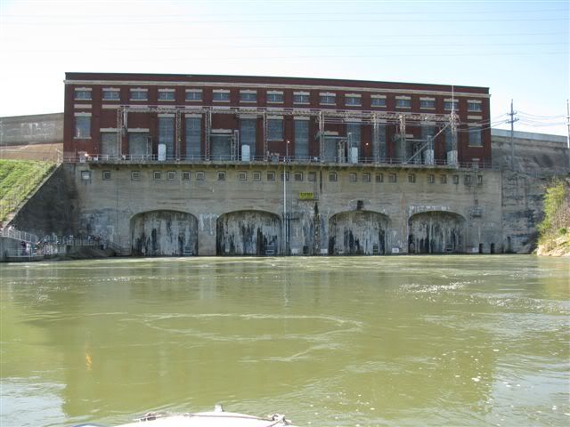
As (the other) Jason mentioned. I also recommend before you venture into the northern waters you first get a LW map showing depths (available at West Marine). Study it carefully and lay in on your dash as well while underway so you know where to go to avoid the shallow parts of the lake. Once you are up to the steam plant the water gets very shallow in certain parts of the lake. Even thought the lake is very wide at the steam plant the water is too shallow in spots even for your boat. But you can make it to Mountain Island if they are releasing enough water. I almost made it all the way in my 240SD but didn't have enough water under me to feel comfortable. Here is a picture of the Mt. Island dam taken by someone at our Marina who made it there in a 205 Sport.
Dave
Last edited:
