It looks like Hannah may hit the Carolinas later this week

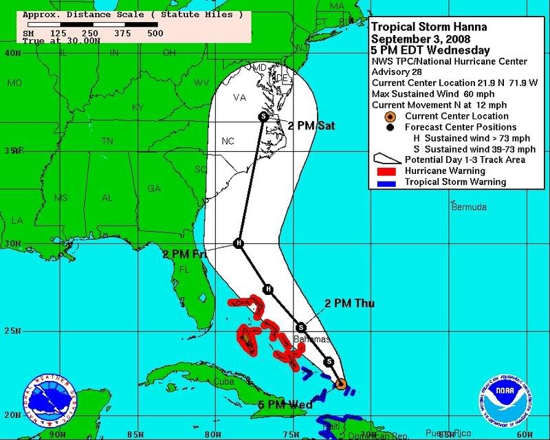
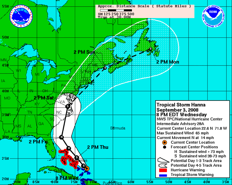
......I hope you folks right in the path on the Coastline make out OK. Looks like the whole Eastern Seaboard is going to have a rough weekend. Dave

And if memory serves correctly and my recollection of the pictures many of you east coasters have shared, you guys have fixed docks and pilings you typically tie to. Around here our tidal swings are so high that our docks are floating up and down the pilings. Fortunately we don't have situations like hurricanes to affect any storm surge.

I remember the last couple year's of storms/hurricanes you guys mentioned having to place boards along the side of the boats so in case the water rises too high it keeps you protected from the pilings and away from the stationary docks.

What do you guys have to do to prepare? and have you?

I know many of you are moored at your own docks and moorages, will this storm surge fill the Chesapeake?
 
I know many of you are moored at your own docks and moorages, will this storm surge fill the Chesapeake?

Depends on the track... With the current track, the answer is "yes". But I don't think the current track is all too accurate as it's been shifting eastward all day.

When Hurricane Isabel hit, it turned into a tropical storm right as it got to the Chesapeake Bay but because of the water being pushed in, there was a huge surge (10 feet where my boat was).

If the track doesn't change by tomorrow at noon, I may get my boat hauled... I'm on a floating dock but the pilings for the bow would be underwater at 10 feet. Actually, the floating docks would come off the pilings at about 10 feet. It hasn't been hauled in a whole week so it's about due anyway.
 
Of course, my marina is just in the process of upgrading the dilapidated travel lift to a new, bigger one... so they can't haul anybody right now! If this is Isabel II then we'll be OK in the water. In Isabel, the town was wiped out but not one boat was damaged--- seeing as how they float and all. I hope the surge stays low. We can handle everything else.
 
Its looking better by the days. Hannah still a low cat hurricane and as this cold front approaches, it may just keep her ugly butt off the coast. We will just sit back and hope for the best for all.
 
Last edited:
Here's the 5 pm map:

a040f753.jpg


Four Suns is located a tad to the NE of the Sat 2 PM location (last dot on the map). The issue is the wind blowing into the mouth of the bay...
 
That's why I don't put much faith in those tracks. I know how they make them and it's not very scientific IMO. The thing could turn into a non-event by tomorrow.

The bigger issue is Ike... Cat 3 now and going to Cat 4 as it plows through the Bahamas and goes just east of FL....
 
Gary I thought about you specifially because of the track and knowing how you're in the south region of the Ches. Best of luck
 
It isn't a hurricane yet but likely will become one. (The tracking and other information shown below should up date automatically as NOAA posts future information).

:smt009:smt009:smt009

With like 3-4 of them lined up out in the Atlantic, I had to bite the bullet...the boat came out this afternoon and is safe and secure on land.

What's worse is that as I was running it up to the ramp, it was about 85 degrees and sunny and the water was sooooooo smooth. Oh the torture! :smt089
 
8pm update tonight didn't change the track...

Hmm... I wonder if this has anything to do with me putting new canvas on the boat.
 
Local Weather Dudes, say that they anticipate it degrading to Tropical storm status as it reaches NC and Virginia.
SO ........I'd prepare for a CAT 5 Hurricane. These guys predict rain everyday and then ask for thanks when we get sun.
 
Here's the 5 pm map:

a040f753.jpg


Four Suns is located a tad to the NE of the Sat 2 PM location (last dot on the map). The issue is the wind blowing into the mouth of the bay...


Mine is located about a half a millimeter to the left of where that thick black line crosses NC :smt089 SB
 
If Hanna follows the center track of the extended forcast map, us Barnegat Bay Jerseyites won't have to haul......We'll be in the upper left (4th) quadrant of the storm and there won't be any water left in the bay to worry about......


hannatrack.gif
 
Dom, I am getting a feeling that us Barnegat Bay guys are going to be spending Saturday morning removing canvas, hanging fenders and doubling up on lines...... sucks.
 
This thing has been shifted to the east a little more.

Guess we'll have to see what the 11am update holds... what a PITA.
 
I will say that Hurricanes do seem to bring out the worst in us as we all wish for someone else's destruction... "hit Florida... hit Florida... go into the gulf... hit Texas..." They have to hit somewhere... and we wish the worst for someone else.
 
From the latest tracking map, looks like the eye is gonna go right through the jersey shore sometime Saturday... What type of wind speed warrants taking the canvas off the arch? I'm thinking anything under 35MPH should be oK to leave on; over 35 take them off?

Here's my list of prep for Friday evening
double-up lines
additional fenders
take dink motor off
take dink out of water and secure on bow
check everything else (power lines, batteries, bilge pump, etc.)
 
Gerry....Why not just (partially) deflate the dink and store it below?
 
I sure hope it shifts more - but I have a bad feeling about this one. My boat is trailered but now I get to worry about trees! Should be a great weekend.... at least my mother in law is thinking of canceling her trip to see us......:smt043:thumbsup:
 
I see now she's been downgraded to a Tropical storm but is expected to gain strength again iinto a Hurricane right before it hits SC and NC,
093226W_sm.gif
 

Forum statistics

Threads
113,247
Messages
1,429,241
Members
61,125
Latest member
Bassinbradw
Back
Top