I am trying to picture what rock you hit. Was it high or low tide?
It was about 5 -5:15pm when I hit, low tide would have been at 9:44pm.
Follow along with the video below to see how to install our site as a web app on your home screen.

Note: This feature currently requires accessing the site using the built-in Safari browser.

I am trying to picture what rock you hit. Was it high or low tide?
"Chart?"
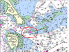
I have been through this area many times. The Channel is well marked and deep, but Bajan obviously got outside the channel and onto the rocks. It is difficult to tell if he intended to be in the channel - he describes "coming from Boston Light" but the channel is half a mile south of Boston Light. Also note that there is no direct navigable path from Boston Light to the Southwest side of Lovell Island, so some clarification is warranted. I realize that many smaller boats intentionally avoid marked channels, but may do so at their own peril.
Even if one is in the channel, it can be a bit confusing at this particular location, where the two channels meet. Advance planning and constant monitoring of position, conditions and other vessels is necessary. Slowing down is best tactic if things begin to happen too fast to keep track of it all. Bajan was going "22-24 mph" (That's 19-21 knots for mariners), which may have contributed to the mishap.
One of the issues that coastal mariners often miss is the age of the data they are relying on. For example, the soundings on chart 13270 were done in 2003 at the most recent, but some date back to pre 1900! the rocks that Bajan hit were last surveyed sometime between 1940 and 1969. Having a chart updated to the latest LNM will help, but updates may miss obstructions outside of normal navigation areas. This is why I stay in marked channels or know areas whenever possible, and if I am in a poorly charted area I go dead slow.
When coming back to the harbor in that channel you need to make sure you are well to the left of that first marker, FlR4s. Its nothing but rocks in there all the way to Boston Light.
There are at least 3 ATONs that flash Red every 4 seconds in that immediate area. Please identify the marker by it's channel and number or light list number so that we know what you are talking about.
I'm not scrolling with my signature. Is everyone having a problem?
As Sea Gull said, FlR4s is NOT a marker number, it's just the indicator that it is a light beacon that Flashes Red every 4 Seconds which stands 35ft above MLW and is visible for 6 miles. But you knew that... By your description you appear to be talking about Marker "4" of the southern tip of Lovell'sThe marker I'm talking about is an iron tower built on a rock pile just to the south and off shore of Lovell's Island, FlR4s. It marks the right side of the channel. I'm not scrolling with my signature. Is everyone having a problem?