Chesapeake Bay Navigation Question...

NaptownLarry

New Member
Apr 29, 2013
17
Riviera Beach, MD
Boat Info
Cruisers Yachts Express 3372, 33', LOA - 36'.
Engines
Merc Cruiser 6.2's with twin V-Drives.
Looking for anyone familiar with the Craighill Channel / Hart Miller Island area of the Chesapeake bay, and making the approach to either of the following locations by water:


  • Row Boat Willies - 9033 Cuckold Point Rd, Sparrows Point, MD 21219
  • Dock of the Bay - 9025 Cuckold Point Rd, Sparrows Point, MD 21219

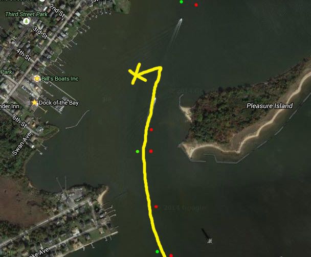
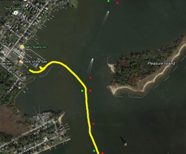
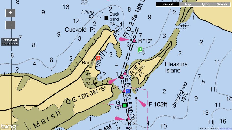
I'm in a 33' Cruisers with a 3' draft... The NOAA charts all say that entire cove is only 2' deep, and every approach I tried from the channel seemed to bear that out. But I saw a couple boats in slips back there that appeared to be significantly larger than mine. So I'm assuming there has to be a way.

If anyone here that's made that approach could screen shot a NOAA map and draw a line showing the approach, that would be great. Failing that, just a written explanation of how to get back there would be greatly appreciated too.

RBWs_zpsamq0qao0.jpg
 
Last edited:
Go in and out at high tide.
 
What kind of depths do you see there at high tide?

And is there any specific approach that's better than any other? Like should I hug the north side where all the piers are, or should I just approach through the middle of the mouth of the cove?
 
Dock of the Bay claims 6ft depth at their pier at mid-tide but I have no personal local knowledge. I've passed by it many times while transiting Pleasure island cut so I'm curious what locals say.
 
hartmiller.jpg

Its been 2 years since I went through on a friends 36 rinker and also a regal with pod-drives... Never had a problem in the channel. Here's a screen cap from Navionics Sonarcharts WebApp. Check it out for further digging on your own. Great resource. Also recommend activecaptain.com for recent local knowledge. It's also free. Go to activecaptain.com and create an account. Then use the interactive cruising guidebook tab to navigate to the area. You can find other users posted routes and tracks there as well.

Example review from AC website:

Date: 2015-05-26
Captain: Larry Holt, Stony Creek Marina (16)

RBW's has a spectacular, sweeping view overlooking the bay and the Craighill Channel Lighthouse from their 2nd story deck bar. They also have their own mini sand beach down by the water complete with picnic tables and palm trees. The bartenders are friendly, the drinks are always cold, they have live music on the weekends, and even on the hottest dog days of summer they'll keep you cool with their overhead misting system. Row Boat Willie's has a floating pier with slips and side docking access depending on the size of your boat. The only catch is that if you're bigger than about 20', you'll have to get in and back out while it's high tide unless you plan on waiting for the next high tide to let you out.It's off the beaten path, but it's definitely worth finding your way here!
 
Last edited:
Its been 2 years since I went through on a friends 36 rinker and also a regal with pod-drives... Never had a problem in the channel.

Yeah, the channel itself is no problem. Even at extreme low tides I've never seen the depths shallower than 7 feet. But what I'm talking about is the cove off to the "East" of the actual channel, where RBW's is located. The NOAA and Garmin charts all show the entire cove at only 2' depth.

Your chart shows it even shallower at only a 1' depth.

There's no way that all those boats in those slips back there made it through just 1 foot of water...
 
Last edited:
I've had my 370 at Dock of the Bay many times, just there a few weeks ago on a friends 27', I take the runabout if going to RBW (for docking purposes). You can not dock at one and walk to the other, they don't like each other. When are you going there? Those places are a 15 minute boat ride from where I keep my boats, I could record the track on my Ipad and post it here if you like. There are some markers that aren't shown on the above picture, they might be on the Garmin Bluecharts on my Ipad, but its on the boat right now.

John
 
Last edited:
I dock my boat at Bill's yacht basin which is the home of Row boat Willies. As you can see I have a 32' Searay and have no problem navigating the channel at any tides. There are also larger vessels that hail from this port. Coming from your direction you need to make a hard left at Red 6 or Red8 and you will see a green day marker in front of you --keep that to port and you will be fine entering into RBW or dock of the bay. RWB has live entertaintment and a beautiful view.
Enjoy and look me up -- on A dock third from end ( no slip #'s)
Rich
 
I've had my 370 at Dock of the Bay many times, just there a few weeks ago on a friends 27', I take the runabout if going to RBW (for docking purposes). You can not dock at one and walk to the other, they don't like each other. When are you going there? Those places are a 15 minute boat ride from where I keep my boats, I could record the track on my Ipad and post it here if you like. There are some markers that aren't shown on the above picture, they might be on the Garmin Bluecharts on my Ipad, but its on the boat right now.

John

Actually I'm up there on a pretty regular basis dock bar hopping in Middle River. So if you could screen shot your 370's Garmin track into RBW's and post it here that would be Awesome. I'm sure I'm not the only one that is missing out on those dock bars because of all the charts saying it's too shallow to get in there.
 
Coming from your direction you need to make a hard left at Red 6 or Red8 and you will see a green day marker in front of you --keep that to port and you will be fine entering into RBW or dock of the bay.

Correct, however when we were entering a few weeks ago, the pole was there but there was not a green marker on it, really made us think for a minute. Maybe they have since put one on, I will check it out this weekend.........FYI, we were at Crazy Tuna this past weekend, looks like Sunset Cove has some competition.

John
 
This first picture was the approach I "tried" and couldn't find anything but 2' depths...

RBW%20Satellite%20Failed%20Route_zpsgkp8ikon.jpg


So is THIS the approach you're saying I need to take to find a clear path ???

RBW%20Satellite%20Good%20Approach_zpsybqxquj7.jpg


Crazy Tuna is a cool place, but they don't really compete for the same crowd as Sunset Cove. Tuna has a nice Tiki Bar, but they cater to more of an older chilled out crowd most days. Plus they have limited slip space, limited parking space, and they don't have the room to do live music there, which presents some limitations... Sunset Cove caters to older crowds for sit down dining, but also to the younger party crowd too. They've got way more dock space, way more outside seating, and live music usually 7 nights a week. I usually dock bar hop throughout Middle River, but my go to place for the night time party is always Sunset Cove. :thumbsup:
 
Last edited:
This thread started out regarding Dock of the Bay (which I am glad has reopened) and Rowboat Willies and then migrated to Crazy Tuna and Sunset Cove. So, where are Crazy Tuna and Sunset Cove located? Another place I enjoy for brunch/lunch is Riverview - no nightlife and REALLY skinny water.
 
Sunset Cove is on Frog Mortar Creek next to Maryland Marina. Head into Middle River and when you hit the 6mph bear to the right and go past Martin State Airport.

Crazy Tuna is next to Riverwatch (if you know where that is). If not come into Middle River to the 6mph. Stay to left of the red/green marker at Wilson Point and then at 2nd green marker bear left into Hopkins Creek. You will see marina on the left - Crazy Tuna just after that.
 
I haven't been to DOTB since it's reopened. I have two friends that attempted to go over in a 340 and and he couldn't get in. I've also heard you want to stay to the right in the channel and stay close to that side making your way through. If I remember correctly there's a lot of rip rap to the left side of the entrance which I think you can see as a thin line on those pictures.
 
Following the original thread theme... There's another shallow entry (on the charts) location that I'd like to add to my dock bar hopping list that's in the same general area...

Brewers Landing Bar & Grille, one waterway south of Middle River in "Back River". It looks good til you hit the inlet at Cox Point, and then all the charts show 3' dropping down to 1'...

Is there any trick to getting in there?

brewers landing.jpg
 
Last edited:

Forum statistics

Threads
113,183
Messages
1,428,129
Members
61,092
Latest member
Ding
Back
Top