Barnegate Bay-Good Luck Point-new bouys

comsnark

New Member
Apr 10, 2007
4,106
NJ Shore
Boat Info
SeaRay SunSport
Engines
5.7LX
Well. . made it south of the Bridge today, in a quest for fuel that was under $3.29 and not stale.

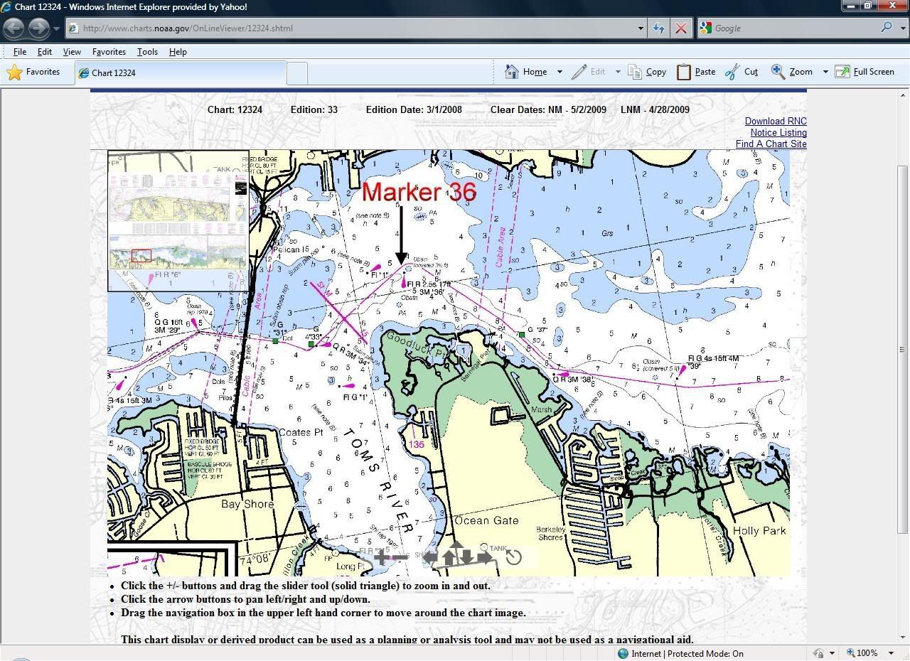
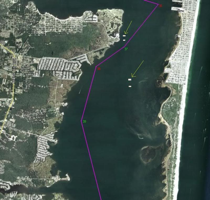
Traveling South from Toms River to Good luck point, I was surpised to see four "Shoal water" bouys (white barrels, red on the ends) about 2/3 of the way from shore to the ICW 40 marker.

At first, I just assumed they were mislaid no-wake bouys (the look is similar), but upon closer inspection. . .YIKES! Last season, I must have run down that area 80 times. Not a few times after dark.

I only got close enough to log the location of ONE bouy on the GPS.

Anyone know the story here?


EDIT: It is not ICW marker 40. As Dom and Ron point out lower in the thread. . I am refering to ICW 36.
 
Last edited:
There was a post either here or another forum recently about this. I believe it was identified as an area that the "Save the Bay" group has organized for an oyster bed rebuilding program. Not 100% sure, but sounds logical.

As a precaution, I have always gone out to the 40 to make turn south.
 
Huh. What a poor location for such a thing. This has to be one of the highest trafficed, high speed areas on the northern bay. And they put four unlit bouys right in the middle. I bet one bouy will be gone by Memorial day, and two more gone by July Fourth weekend.
 
In the Manasquan they don't even have the regular no wake bouys out yet. Idiots still pass our marina within 50 yards doing 45 MPH.
 
Yeah. . .usually June for those to go out. Also, the Bay racing barrels are not out yet either.
 
Is 40 the marker you have to go way east to hit? I always cut that one but no more than 100'.
 
Ron....I think you're talking about ICW36.....the one over towards Seaside side of the bay and just north of the bridge where you rafted last year.
 
Hmmm. Makes me wonder if I have the right number.

The 40 I am thinking of is just off Seaside Park south of the bridge. . just South of Toms River. Yeah. . you go way east to hit it. In fact. . I don't think I have ever seen a boat East of that marker. Most people go well West . . .more than halfway to shore where the old radar net was/is located is where my GPS tracks lie.
 
#36 is shown here. It's south of TR and south of Seaside Park, adjacent to Island Beach State Park. I'll usually cut it right along the longitude line which takes me btwn the marker and the OBSTN (if there's really one there). ANYWAY, is this where the floating buoys are now to be found??

Marker36.jpg
 
36 is north of Seaside park and adjacent to Seaside Heights. IBSP is south of 36.
 
I posted this on another board about a month ago....

I was out on the Barnegat Bay this past Sunday, just south of Toms River. The Pic below is a 'representative' of the ICW in the areas betwwen markers 36 through 39.

nowakebuoysBB.jpg


The Yellow lines are pointing at two sets of two No Wake barrels and the general area where I saw them. That is VERY unusual to see. A lot of times you will see big orange temporary barrels to mark off a 'sailboat race'. These, however, are official No Wake barrels.

I'm guessing some kind of research project? Rutgers maybe?

Does anyone know of anything going on? Are there more out there?
 
I was thinking they were set up for an upcoming snailbloat race? Oh wait, that's right. They race directly into the ICW on busy weekends, not off to the side of the ICW.:wow:

Dom, not to split hairs but according to your drawing, 36 is exactly at the border of SSH and IBSP.:grin:
 
Last edited:
This was a followup article a few days later in the local paper...

From this morning Asbury Park Press, this may have something to do with the no wake barrells....

http://app.com/article/20090430/NEWS02/904300431/1070/NEWS02

Barnegat Bay dredging funds approved as part of stimulus package
Feds fail to include beach replenishment projects
By NICHOLAS HUBA • MANAHAWKIN BUREAU • April 30, 2009


Money to dredge Barnegat Bay has been approved as part of the federally funded stimulus package, but funds for additional beach replenishment projects — such as erosion studies and long-term nourishment efforts — were not included.

The state has received approximately $2 million in funding for maintenance work across South Jersey and the Shore area.

"During these tough economic times, it is disappointing that these important recovery funds will not be going toward beach replenishment projects, which are critical to our shore communities," said Rep. John Adler, D-N.J. "But I am pleased to see nearly 2 million dollars directed to protect the New Jersey Intracoastal Waterway and Barnegat Bay."

Army Corps of Engineers officials have said that not receiving funds from the stimulus package will not impact currently planned projects, such as the pending beach replenishment project in Harvey Cedars.

The projects that will receive funding through the stimulus package include:

$1.26 million for maintenance dredging of the remaining critical shoal areas within the New Jersey Intracoastal Waterway.

$350,000 for maintenance dredging to protect Barnegat Bay.

$300,000 will be used to prepare a regional systems-type study for the coast of New Jersey; develop a regional sediment budget and an improved understanding of regional coastal processes; and implement an efficient regional sediment management and monitoring program to reduce long-term nourishment costs.

Adler has been critical of the administration removing the funding for beach replenishments projects from the stimulus package. In late March, Alder sent a letter to Peter Orszag, director of the White House Office of Management and Budget, asking him to leave the money.

"On behalf of my constituents in Ocean County, I urge you to maintain funding for beach nourishment projects," Adler stated in the letter to Orszag. "The money included in the American Recovery and Reinvestment Act is necessary to conduct beach erosion studies, build groins and jetties to protect beaches from surf, storm surge and tidal currents, and long-term nourishment efforts like pumping tons of dredged sand back onto eroded beaches."
 
This was from the LNTM....


This may explain the barrels north west of ICW 37...

NJ – BARNEGAT BAY – SHOALING
A shoaling area consisting of crushed clam shells has been reported near Goodluck Point in Barnegat Bay at approximate
position 39-55.500N, 074-06.109W. Chart: 12324 Ref. LNM 53/08
 
When are they starting the canal connecting the Manasquan and Shrewsbury Rivers?
 
Dom and Ron: Yes, thanks for correcting me. I was refering to ICW 36, not ICW 40. I posted an edit into the original post.

Dom's photo is correct. That's where I saw the markers. Near 36. the markers are a set of 4 barrels arranged in a square about 100' on a side. They look EXACTLY like no wake bouys. . .but if you approach close. . they say "shallow water".

I was coming South to Good Luck Point Marina and I was actually planning to cut significantly to the WEST of these barrels. . they looked unusual enough that I turned to investigate closer (and log them into the GPS).

I was not in the mood to get close enough to really judge the depth in the area. I probably will get really close in a week or two to more accurately log the location of these barrels.

Dom's photo also shows another set of barrels out near ICW 37 and ICW 38. I saw these as well. . . but it is far enough out of the ICW and I did not approach close enough to verify if there were 2 or 4 (I saw two. . but there could have been two more), or close enough to read markings.
 
I stand corrected. Confusing my marker numbers. I believe 40 is west of Tices Shoal. 36 is truly east of Good Luck Point. Sorry, it's been a long Winter.
 

Forum statistics

Threads
113,186
Messages
1,428,166
Members
61,096
Latest member
380Thumper
Back
Top