Backup GPS

comsnark

New Member
Apr 10, 2007
4,106
NJ Shore
Boat Info
SeaRay SunSport
Engines
5.7LX
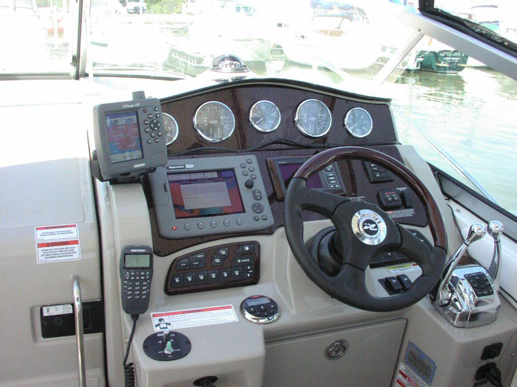
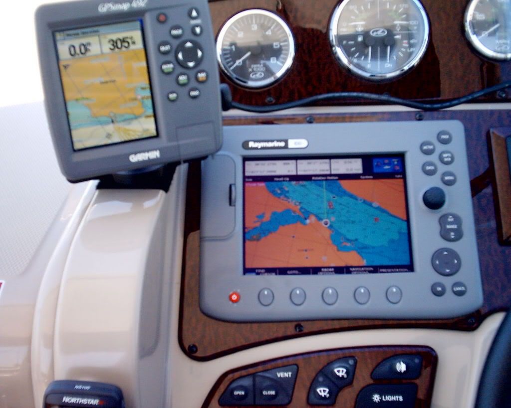
There are a few threads in the Electronics section, a few have commented on using Garmin Nuvi units as a Backup GPS.

Rather than Hijack one of those threads. . .I would like to ask people's thoughts on the "need" for a backup GPS on your boat.

Have we gotten to the point where paper charts are completely superfluous?

Where I boat, which is basically coastal stuff, I also considered "local knowledge" as the backup to my GPS. Thinking about it, I suppose I really am dependent on this piece of technology, especially when running at night.

- - - - -

As a side topic- anyone use the "G2 Vision" cards? Waste of money, or valuable tool?
 
Backup GPS? I don't see a need for it. There is no place to mount one on Just Ducky either. If I had a 48DB, for example, then I'd have a dedicated nav system and a PC based nav system, each integrated, but redundant. But it wouldn't be something needed, but could something easily accommodated and useful.

Paper charts are more than sufficient as not only a backup but also a primary. I ran up and down the coast for years with just a Loran that reported numeric position data and paper charts. The loran just backed up my ded reckoning on the paper charts. I also flew around quite a bit using just sectionals and pilotage with a few VOR vectors occasionally referenced to check my navigation. Never used GPS in the air.

I'm almost tempted to say that if you need a backup GPS, that you should check your navigation skills, but I'm going to stop short of that.

Best regards,
Frank
 
I have a backup GPS and I find it very useful. This year I pretty much boated in unknown waters every weekend. One weekend my main GPS went down due to a bad antenna connector. With the backup, no worries. Is it needed? probably not, but it sure is nice to see where all of the rocks are.
 
I agree with Frank's sentiments. I have learned to navigate with a compass and charts for the very important level of safety it provides. Still, when I have ventured into unfamiliar waters, I have taken along an old handheld. It is not a chartplotter, but since it gives precise location, I can verify how I am doing with the chart. I like the piece of mind.
 
I prefer to use a backup GPS. I have a Garmin GPSMAP 492 that mounts with VELCRO and is very helpful when we are on the water. Here are a couple of photos of how it is attached.

I now have cable clips that keep the Garmin cable snug over the Raymarine unit.


Anytime02Jun08-16.jpg


Anytime02Jun08-1.jpg
 
I guess it is the technology today feeling, but how many times have you been to a store when the clerk could not figure out how much change to give you when the “computer went down”.:huh: Fall back on a backup? If you are going out on a road trip, do you plan it on a map?

I often test my navigation skills (which still need plenty of work) by planning trips and running with just the buoy markers and compass leaving the GPS on radar only screen. The GPS is a fantastic tool for today’s boater but even as a newbie to boating I recognize the need to be able to read, understand, and follow charts. I have no need for a backup GPS.
 
I use a Garmin 276C as my backup. I don't think having a backup GPS is reason to challenge anyones knowledge of where they boat or their boating skills. Rather I consider it thinking ahead.

Kinda like having a spare tire in your trunk, one never plans on having a flat.

And to boot, when I am running at night, both my GPS's are on.
 
Last edited:
I use a Garmin 378 as my backup. I don't think having a backup GPS is reason to challenge anyones knowledge of where they boat or their boating skills. Rather I consider it thinking ahead.

Kinda like having a spare tire in your trunk, one never plans on having a flat.

And to boot, when I am running at night, both my GPS's are on.

I would not call it a “challenge” to anyone’s knowledge, I just subscribe to the “if you don’t use it you loss it” theory. At my age I have found it to be very true. :thumbsup:
 
I just subscribe to the “if you don’t use it you loss it” theory.

Oh no! I better talk to my wife. I'd hate for it to fall off because of insufficient use!
 
Good navigation skills are priceless and while a backup GPS might be a bit of a luxury to most, what happens if a total electrical failure occurs...?
Get a back up if you want, but keep the charts handy.
 
I have a backup VHF too. Maybe I could just practice yelling louder instead. I don't understand how having a backup of an item you feel is important or adds to the value of a trip is a cop out.
 
I have a stand alone GPS that also drives a plotter and is interfaced to the autopilot so I can navigate with either. I have a second redundant plotter that has its own DGPS and WAAS receivers that is also interfaced to the AP.

Since I also always use paper charts when I'm not local, I don't know that the GPS and plotter redundancy is necessary, but it sure is nice to be able to see a plotter and radar at the same time. Even nicer is to be able to see 2 plotters displaying the same thing in different scales. I find that very helpful when approaching a port or harbor I'm not familiar with since it allows me to leave the AP set on a planned waypoint while I look at or set up a future route in a much smaller scale.
 
My Garmin 276C is battery powered as well, so in the event of power loss, I still have that at hand.

I also keep a map of our lake at hand at the helm. Cannot tell you how many times I pickup the map before looking at the GPS.

Maybe we do rely a bit much on technology, but I have to ask: would you rather have a sales clerk trying to figure up your totals and change over the register that tells them the answer? Had that happen to us, poor little girl. Finally I had to tell her how much change she needed to give us back.

And now being much older, my eyes don't see quite as well as they used to and my night vision sucks. So its pretty nice to have GPS to look at!

(Had to correct model number of my backup, it's a 276C not a 378)
 
Last edited:
My Garmin 276C is battery powered as well, so in the event of power loss, I still have that at hand.

I also keep a map of our lake at hand at the helm. Cannot tell you how many times I pickup the map before looking at the GPS. .... And now being much older, my eyes don't see quite as well as they used to and my night vision sucks. So its pretty nice to have GPS to look at!....

Nowhere in this series of posts did anyone state that they only use GPS for charting/plotting...the title of this thread is "Backup GPS".

I also prefer to use the available technology in my everyday life as well as my boating life. I plan my trips first using paper charts and then I use MAPQUEST with the latest NOAA charts, calculate waypoints, etc. and then electronically transfer the data to both of my GPS units.

I have been using paper charts since the mid 1950s and even though I still have them and know how to use them, I will continue to primarily use my GPSs while underway. In addition to the two GPSs mounted on the console, I have a portable battery operated GPS (iPhone) in my pocket. It is pretty accurate and easy to use. Like TAWCAT, my aging eyes are nowhere as sharp as they used to be, making the GPS a much safer option for me.

Without this wonderful technology, we would be writing these postings on the seawall in Georgetown and I would be taking trips there to read the "latest" every 2 to 3 months instead of perusing them on the internet (at my convenience). How many of you need a calculator to perform algebra/calculus, etc, instead of making a paper calculation? I purchased my first calculator while in Japan in 1970, long after high school and my secondary education. I primarily use the computer keyboard for 99.999% of my writing, but I still know how to write, though, not very legibly. I guess someone will criticize this, too.
 
I have paper charts somewhere on the boat. I only know that because I saw them in a load i took off the boat for the winter. I do all of my trip planning on google earth with EarthNC, paper charts seem so 1800's. I understand their value when all else fails, kind of like knowing what leaves not to wipe with when you are camping and run out of toilet paper. but with 3 GPS systems on my boat (2 battery powered) it's going to be one rough trip before I dig them out. My backups serve other functions like taking pics and emailing so they don't just sit there waiting for my GPS to break.
 
Nowhere in this series of posts did anyone state that they only use GPS for charting/plotting...the title of this thread is "Backup GPS".

I also prefer to use the available technology in my everyday life as well as my boating life. I plan my trips first using paper charts and then I use MAPQUEST with the latest NOAA charts, calculate waypoints, etc. and then electronically transfer the data to both of my GPS units.

I have been using paper charts since the mid 1950s and even though I still have them and know how to use them, I will continue to primarily use my GPSs while underway. In addition to the two GPSs mounted on the console, I have a portable battery operated GPS (iPhone) in my pocket. It is pretty accurate and easy to use. Like TAWCAT, my aging eyes are nowhere as sharp as they used to be, making the GPS a much safer option for me.

Without this wonderful technology, we would be writing these postings on the seawall in Georgetown and I would be taking trips there to read the "latest" every 2 to 3 months instead of perusing them on the internet (at my convenience). How many of you need a calculator to perform algebra/calculus, etc, instead of making a paper calculation? I purchased my first calculator while in Japan in 1970, long after high school and my secondary education. I primarily use the computer keyboard for 99.999% of my writing, but I still know how to write, though, not very legibly. I guess someone will criticize this, too.

I am truly sorry if you took my post as “criticism”. It was not intended that way. I was just trying to convey my thoughts on relying so heavily on today’s electronics. Hell the worst punishment in the world I could inflict on my daughter would be to take away the computer. I guess I need to work on my communication skills as well.
 
I don't have a backup GPS but I think it is a good idea. After al, safety is job 1 and anything that can enhance our ability to bring the family home safe in a bad situation is a good idea.

I always have the appropriate charts at the helm. I feel naked (not a pretty site) without them. But I navigate very much by GPS. I like to follow the charts at the same time as it gives an instant "big picture."

A few years ago I was running the bay under very bad conditions and very low visibility when the GPS went out (fuse). I was glad I had "some" navigational skills using paper charts as we rewached our destination fine.

A backup GPS is on my wish list right after a new dinghy.
 
I have a Northstar primary chartplotter, and follow along with the charts to help with those skills.

As a backup, I have a handheld Garmin ETrex.

Failing that, I have a compass.

I also keep a handheld VHF onboard as well.

I don't like to be without my electronic toys. Barring total power failure and dead batteries, I should be OK to figure out where I am going.

Cheers,

Randy.
 

Forum statistics

Threads
113,262
Messages
1,429,612
Members
61,140
Latest member
Terminator04
Back
Top