Back to Bimini ...

Asureyez

New Member
Apr 22, 2007
1,535
Ft. Lauderdale, Fl.
Boat Info
Sea Ray 460 Sundancer Hardtop 2001 - SOLD
Engines
Cummins 450 Diesels
Hey Mates:

Slipped the ropes last Friday to run to Bimini to join in the party surrounding a YC Fishing Tourney (I don't fish my boat). I had aboard a fellow YC member and his guest ... the Admiral had shoreside obligations that needed attention so I was stag. Both my quests we experienced coastal boaters but they had never taken a boat out of the sight of land. This was a training mission for them and I let them run the boat for experience so they'd be more confortably taking their own (non Sea Ray Boat to Bimini and beyond)

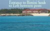
We left the slip ay 7:45 AM and tied up in Bimini just before 11:00 am. The Cummins 6c's ran flawlessly and despite forecasts for 3-5 foot seas we crossed in truely flaaaaaaaaat seas ( .5 to 1 ft) and clear skies.

We cleared Bahamian formalities w/o a hitch, but fair warning clearing in Bimini is a hassel due to construction at Government House causing immigration and customs to be at opposite ends of Alice Town. Nonetheless, we were back at the Bimini Big Game Club marina for lunch by noon.

Grabbed a leisurely lunch and then set out to explore the reefs off No. Bimini. We took Asureyez reef hopping, in 10-15 ft of water, hunting reefs off the beautiful beaches. Unfortunately reefs were not to be found where we looked and we snorkled (with a Brownie Third Lung) over grassy banks out to 28 feet. ... scant fish observed.

Saturday we were totally rained out for scuba ... high winds and squals ruled the day. Thankfully it cleared in the late afternoon for the pool party & festivities. A good time was had by all ... I think.

Sunday we at breakfast in the marina bar ... their french toast is absolutely the best on the planet. And I scounted up some more dive weights, the water was so salty, I needed twice the weight for me as did my guests.

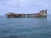
We left the Big Game Club about ten and went south out the southern pass of the Henrry bank and went past Turtle Rocks and turned to port and east bound to the wreck of the "Sapona" a concrete open ocean barge from the second world war that is sunk in 15 feet of water (pics below). We cranked up the Brownie and snorkled the ship ... the fish were napping I think. But the horse flies were out for blood and we pulled the hook and set out for Pt Everglads without lingering to get the blender cranking.

Ran back to Lauderdale in again marvelous flat seas and a following 5-8 knt wind. As we apporached Florida we had massive storms forming over Florida, we we buttoned up and got ready for heavy weather. We broke the jetties at Pt. Everglades in a whiteout squal with radar saving the day.

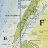
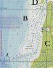
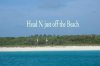
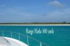
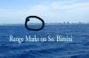
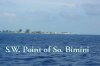
Navigation pics follow, I'll get more pics from my guests and get them up as well.
 

Attachments

  • bimini_sands_channel_755.jpg
    bimini_sands_channel_755.jpg
    23.3 KB · Views: 733
  • new_channel_no_end_henry_bank_359.jpg
    new_channel_no_end_henry_bank_359.jpg
    14.4 KB · Views: 734
  • head_no_fm_marks_185.jpg
    head_no_fm_marks_185.jpg
    15.6 KB · Views: 746
  • range_marks_600_yds_208.jpg
    range_marks_600_yds_208.jpg
    17.2 KB · Views: 746
  • range_marks_on_so_bimini__1_mile_off_115.jpg
    range_marks_on_so_bimini__1_mile_off_115.jpg
    24.7 KB · Views: 740
  • sw_point_of_s._bimini_333.jpg
    sw_point_of_s._bimini_333.jpg
    20.9 KB · Views: 739
Last edited:
Fuel data ... About 7 hours run time plus 3 hours lower revs entering and leaving ports, total hours 10.1, fuel 210 gals including 10 hours of gennie.

Figure 200 gals for 10 hours avg., 20.0 gals per hour curise and low speeds around Bimini. That is a substaintial improvement from our Abaco fuel burn ... valve adjustment helped a lot. :cool:
 
Oh man I'm so jealous. Two trips in a month? that water is so blue. pics are great. :thumbsup:
 
Asureyez you have good eyes finding those range markers. I do not have your experience and have never done this trip so please excuse these questions. How did you find the range markers? Was local knowledge required to run the course into your anchorage? Did you set the waypoints and have your GPS to carry you in?

Thank you

Paul
 
Those Tiny Stakes ...

Paul:

Once I get within a mile of the landfall I no longer use GPS for Nav, switching to Mag Compass, Radar and visual data. When making land fall I establish my initial waypoint at about a mile off and further south of where a chart tells me to end my crossing. I then always know to head left (to port), to set up a run parallel to the coast to find my range. I do this for Bimini every time I go, and that is why I'm a little closer to the SW point on South Binimi than a chart might tell me I need to be. Then I come up to a NNE heading running parallel with the coast to pick up the range marks which will appear as two stakes, the lower one set to the left. I know what it should look like and once I get the range marks in my sight I begin to run the range from deep water and establish my magnetic course. The I run by compass heading and visually steering to keep the stakes aligned so as to appear as one stake.

I constantly recheck the markers in Bimini because the possibility of seeing a dead tree as a range marker is high, I do not commit to entering shallow water until I know I have the right markers for my range. Charts may show these stakes as being lighted but that is more a wishful thought. If making this landfall at night, which I've done, plan on a lot of Puckering.

I think entering Alice Town is one of the most complicated landfalls I've made in that there is open following seas to my stern, a beach very close to my bow, a narrow channel bounded by serious shoals leaving little room for error as I pick my way through in a serpentine course to the port entry.

The skipper allways earns his pay for a safe landfall, a steak dinner is certainly the order for Bimini. Like many things in boating local knowledge makes things kids play, but this Harbor's characteristcs and challenges can change rapidly with weather and tides. Storms can change the bottom character so rapidly shifting shoals to make all you know obsolete over night make each Bimini landfall a new experience! That's why I've always been so eager to get "local knowledge" about a port of call, before having to run it my self.

You'll notice most of my personal picture taking is port entries, land mark and geographical features, bouys etc. for my navigation library, my Admiral snaps the flowers and local sights.
 
Bimini water

The near beach water in Bimini is the most beautiful Azure Blue i've ever seen in my life. When I met my then Admiral to be, her yes immediately made me thingk of the water around Bimini ... Asureyez a contrived name for the Admirals blue eyes which are Bimini Blue!
 
The Wreck Sapona

Due south of Bimini on the Great Bahama Bank is the wreck of the Sapona, a concrete ship made in WWII. She was designed to be towed by larger ships to carry bulk cargo. Its history I do not know but she sits on the bottom in 15 feet of water. The Sapon ai on your charts and is about a mile east of Turtle Rock Light just about a mile south of South Bimini island.

The sea bottom is grass and small corals . We snorkeled around this behemoth and it teams with small fish and opportunistic barracuda.

The only draw back is the wreck seems to be home for a zillion horse flies which pounce the moment you cut the throttles. I broke out a can of Yard Guard to beat them back ... but they seemed to like the taste of Allrethrin almost as much as blood. The relief came from being fast in swatting the pesky devils.

We used the Hooka rig here, but with many small boats coming and going, We had to leave some one on deck to flag off approaching vessels who arrive like the swarms of horse flies. It amazes me that skippers bring a boat to a special spot to dive, see other boats there first and expect to blast through the anchorage at full throttle looking for their spot ... a pet peeve.
 

Attachments

  • sapona_from_east_937.jpg
    sapona_from_east_937.jpg
    22.8 KB · Views: 674
Last edited:
Well, we were there at the same time. We came in Thurs am with the Bahamas Tourism boating Fling and stayed at Big Game. We did the Sapona on Thurs afternoon, Honeymoon Harbor on Friday, and Three Sisters on Sat. We were at the Tackle Box alot for dinners and drinks, as well as The Red Lion, Johns, & End of the World bar. I agree on the bugs. Worst I have ever seen it there. We came back yesterday morning. It took us longer to clean in then it did the ride back. Very frustrating. But the trip was great!
 
I have just GOT to do some southern boating......that water looks beautiful.....
 
I'm up for adoption to anyone with a boat living in florida.
 
Navigation

Paul;

I would recommend you hone your pencil & paper navigation skills using larger paper charts, a compass, right triangle, parallel ruler,a speed log, a watch and pencils.

With these simple tools a skipper can navigate coastal waters with little more outside input that line of sight landmarks, the suns shadow and direction of sun rise and set.

I'm concerned that with the widespread use of inexpensive GPS and electronic charting that few skippers can function if the power goes out because they never received the training to get from A to B the old fashioned way.

A boat owner doesn't have to go to school to gain these skills, just read and practice from several coastal naigation texts that establish the underlying technique and mathematics on which most modern electronic navigation is based.

Some years ago a few college kids sailed from San francisco in a 27 ft sailboat to Hawaii, with the only navigation tools on board being a single sailing chart, a parallel ruler, pencils and a transistor AM radio. They made Hawaii over some 3000 miles of open ocean with little resources but obtained several dedreconing fixes a day and maintained a sucessful rumbline course where a 1/2 degree variance in heading over the three thousand mile journey would have casued them to miss the Hawiian chain entirely.

We today have the luxury of getting the nav served up to us on a gold platter for a few dollars. However, all that technology is useless with out electricity. I believe a skipper should be able to get to where ever he intends to take his boat no matter what happens to the satellites or the electricity aboard. As long as he has the basic tools of compass, relevent chart, and ruler and a pencil he should be able to get to his boat to its destination safely.

Too really expound on my frustration on this point, the boat mfg's. have even begun to build out of their designs any place on a power boat under 60 feet for a actual nav station where basic chart navigation tasks can be performed ... just try to walk a rumb line on your chart on the deck of our beloved SR express type cruisers, heck even the EB's are devoid of a 2x3 flat surface in proximity to the helm. I know on my 460, even the salon table is too small.

Have a good grounding in the old school skills allows a modern era skipper to be a great navigator with the electronic tools we have today. Why, because they understand the principals involved and have the confidence that thay can get home with out the gadgetry if need be.

<stepping down from soap box>
 
Bimini Navigation notes

Follows are two pics with overlay annotations and explantions of what is there and how to nav the landfall at South Bimini and in to Alice Town on North Bimini.

I've scanned an actual chart but it is for referance only and should not be used for actual navigation purposes. All depths ar ein METERES

Chartlet one illustrates the entrance over the reef at the south end of South Bimini, the run along the beach behind Henrry Bank, the wiggle around the Bimini Shores Shoal, the new markers at the noth end of Henry Bank , the entrance to Alice town Harbor

Charlet 2 illustrates the entrance to Alice Town Harbor and the manuvers inside the harbor as far north as Big Game Club.
 

Attachments

  • chart_c_111.jpg
    chart_c_111.jpg
    48.3 KB · Views: 336
  • chart_b_171.jpg
    chart_b_171.jpg
    48.7 KB · Views: 342
Boating in the Bahamas

When boating in and near the islands the water is alwasy pretty skinny ... Bimini just has a unique entrance adn is subject to change as the channel is within 1.5 miles of a 3000 ft shelf which can run a lot of water uponto a very rapidly shoaling island.

But in fair weather it's a hoot of a place to go to and the fishing is fantastic.
 

Forum statistics

Threads
113,173
Messages
1,427,884
Members
61,086
Latest member
MrWebster
Back
Top