- Nov 26, 2006
- 7,628
- Boat Info
- 2008 44 Sedan Bridge
- Engines
- Cummins QSC-500's
Straight Drives
30 Oct - We collected our stuff for the weekend and loaded up the boat. Winds were forecast to be NE at 10 - 15. East Bay would be choppy, but the ICW would be fine (as always). Our primary direction to cruise was SE, so NE winds were perfect for taking the boat outside, so we did.


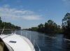
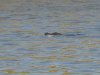
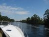
We left the dock around 10:30 in the AM. We had to go about 5 miles NW to the pass, then SW out the pass, then SE along the barrier island (Shell Island) on Shell's Island. It was crystal clear and the dolphins were out in numbers. After about an hour, the sight of the fish ripping across the surface at the bait fish was too much to pass up, so we slowed down off plane and threw out some silver lures and made a few circles - no luck, but it sure was pretty.
http://maps.google.com/maps?hl=en&ie=UTF8&t=h&ll=29.963263,-85.518265&spn=0.412841,0.55481&z=11
Back on plane to the SE to Port St Joe. We idled into the inlet that leads into the ICW. 2 miles inland, there's an intersection to the ICW. West to PCB, East to Apalach. We idled in at just a couple of knots and got lods of nods and waves from the local folks fishing in very shallow boats. That intersection marked the 44 mile point from our dock, whether we went inside or outside - it's the same either way.
http://maps.google.com/maps?hl=en&ie=UTF8&t=h&ll=29.861488,-85.292358&spn=0.206632,0.277405&z=12
As we continued to the East, an American Bald Eagle graced us with a low pass.

There were a few boats along the last 30 miles to Apalach, so a quick call on the radio helped coordinate a friendly pass that worked for each party involved. As we entered Lake Wimico, there were some very shallow areas and a lot of debris. Caution paid off.
http://maps.google.com/maps?hl=en&ie=UTF8&ll=29.769742,-85.099068&spn=0.206821,0.277405&t=h&z=12
As we continued East, the flow of the river sped us along. That, combined with being about 70 gallons lighter, allowed the 340 to hit 25 knots at 3350 RPM and only about 29 gph. We cruised into the Scipio Creek along some new condos and up to the fuel dock at the marina. A beautiful 3 hour cruise. The gas truck was there so gas was dropping from $3.679 to $2.959. We took on a 100 gallons and saved $70 (we started the trip at 3/4 gas). On to our parking spot on the center dock where we inflated the dinghy and then headed inside for our first of several dozen, fresh, Apalachicola oysters - mmm, mmm, mmm, good.


As the night fell, more friends joined us. The guys gathered up a truck load of firewood and two outdoor heaters and started the evenings festivities. More to come (pictures tomorrow at home, I'm at work - again).


We left the dock around 10:30 in the AM. We had to go about 5 miles NW to the pass, then SW out the pass, then SE along the barrier island (Shell Island) on Shell's Island. It was crystal clear and the dolphins were out in numbers. After about an hour, the sight of the fish ripping across the surface at the bait fish was too much to pass up, so we slowed down off plane and threw out some silver lures and made a few circles - no luck, but it sure was pretty.
http://maps.google.com/maps?hl=en&ie=UTF8&t=h&ll=29.963263,-85.518265&spn=0.412841,0.55481&z=11
Back on plane to the SE to Port St Joe. We idled into the inlet that leads into the ICW. 2 miles inland, there's an intersection to the ICW. West to PCB, East to Apalach. We idled in at just a couple of knots and got lods of nods and waves from the local folks fishing in very shallow boats. That intersection marked the 44 mile point from our dock, whether we went inside or outside - it's the same either way.
http://maps.google.com/maps?hl=en&ie=UTF8&t=h&ll=29.861488,-85.292358&spn=0.206632,0.277405&z=12
As we continued to the East, an American Bald Eagle graced us with a low pass.
There were a few boats along the last 30 miles to Apalach, so a quick call on the radio helped coordinate a friendly pass that worked for each party involved. As we entered Lake Wimico, there were some very shallow areas and a lot of debris. Caution paid off.
http://maps.google.com/maps?hl=en&ie=UTF8&ll=29.769742,-85.099068&spn=0.206821,0.277405&t=h&z=12
As we continued East, the flow of the river sped us along. That, combined with being about 70 gallons lighter, allowed the 340 to hit 25 knots at 3350 RPM and only about 29 gph. We cruised into the Scipio Creek along some new condos and up to the fuel dock at the marina. A beautiful 3 hour cruise. The gas truck was there so gas was dropping from $3.679 to $2.959. We took on a 100 gallons and saved $70 (we started the trip at 3/4 gas). On to our parking spot on the center dock where we inflated the dinghy and then headed inside for our first of several dozen, fresh, Apalachicola oysters - mmm, mmm, mmm, good.
As the night fell, more friends joined us. The guys gathered up a truck load of firewood and two outdoor heaters and started the evenings festivities. More to come (pictures tomorrow at home, I'm at work - again).
Last edited: