When are the seas too rough to take the boat out?

Gary, how would I know if the wind is decreasing? From broadcasts over time increments?

Pull up a plot on your Navigation PC that is tied to the wind meter on top of the boat...

AND...

I use the PORTS system:

http://tidesandcurrents.noaa.gov/ports.html

If you look at the Chesapeake Bay Bridge Tunnel weather station, it looks like this:

3WLWind_bb.png


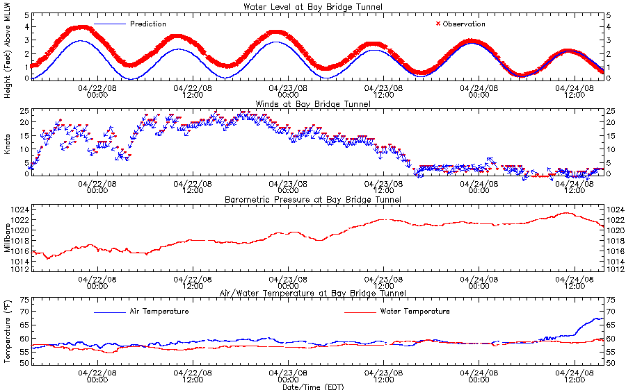
So when the wind was at 25 knots and decreasing a few days ago, I would have been OK going out as long as the forecast supporting a continual drop in wind speed and wave height. If the wind was at 15 knots and going up, I would stay at the dock... You can't base everything on this but I like looking at trends of real data as well as the forecast and sat images. You can also see on the tide level that the waves were knocking the sensor all over the place showing a rough plot.

I also have WxWorx on the boat so I can get buoy data from that.
 
"Pull up a plot on your Navigation PC that is tied to the wind meter on top of the boat..."

More stuff to buy? Damn man, I need to take a 2nd & 3rd job now to pay for all this stuff, delivering pizzas at night and delivering the paper in the morning.
 
There are a lot of Internet sites out there that show buoy data... find one you like and use that before you leave port. Basically I like to see the forecast, the real time data, the weather maps, the sat images and then tie that to some experience and I feel comfortable dealing with the weather. I will say that the "real time" weather, like WxWorx or Sirius and seeing the Nexrad radar and buoy data underway is well worth the cost if you cruise a lot. Being caught in squalls just plain sucks.

BTW, looks like a great day to be on the water....
 
Last edited:
What is wrong with the regular marine weather forcasts available on your VHF or many websites for day boating?

Here's an example:

Synopsis For The Suwannee River To Destin Out To 60 Nm
Synopsis
A high pressure ridge will remain across the marine area through Sunday...with winds being influenced by nearshore afternoon sea breezes and a slight increase in easterly winds at night. A cold front will move east through the coastal waters Monday..accompanied by scattered showers and thunderstorms.
Forecast as of 2:17 PM EDT on April 24, 2008
Apalachee Bay-
Coastal Waters From Apalachicola To Destin Fl Out 20 Nm-
Coastal Waters From Ochlockonee River To Apalachicola Fl Out To
20 Nm-
Coastal Waters From Suwannee River To Keaton Beach Out 20 Nm-
Tonight
East wind around 5 knots...increasing to around 10 knots after midnight. Seas 1 to 2 feet. Protected waters smooth to a light chop.
Friday
East wind 10 to 15 knots...becoming onshore around 10 knots in the afternoon. Seas 2 to 3 feet...except 1 to 2 feet in Apalachee Bay. Protected waters a light to moderate chop.
Friday Night
South wind around 5 knots...becoming southeast 5 to 10 knots after midnight. Seas 2 to 3 feet...except 1 to 2 feet in Apalachee Bay. Protected waters smooth.
Saturday
Southeast wind 5 to 10 knots. Seas 1 to 2 feet. Protected waters smooth.
Saturday Night
Southwest wind around 5 knots. Seas 1 to 2 feet. Protected waters smooth.


Perhaps I am just an analog boater, but it doesn't take tons of on-board electronic gee-whizz to be safe and have fun. Maybe this is another one of those "because it can be done" things............
 
Frank,

If you want me to kick him off the board, just let me know :smt043I have been looking for a reason :lol:

Wesley
 
"A rule of thumb is that a boat can handle seas up to 1/2 it's length"

I'd like to know the source of that particular guideline. I must be a real wuss ........ I"m not going to be out in 22'+ seas.


Yes, taking out a 240 sundeck in 12 ft seas sounds reasonable.... :(
 
Wesley....

Look at it like this: Gary is like the lead weights on the CSR wheel...we need him to keep things in balance........Oh wait, providing balance seems to be my job as the nerds turn a boating forum into a geek hang out.

By the way, I'm still waiting for the nerds to answer my question on what NMEA2000 means to those of us who already own boats with electronics on them........and notice they passed on the "what is wrong with regular marine weather information" question as well........
 
I have all of this setup on my computer and phone. So when I wake up in the morning I have all of the NOAA sat and radar images, tides, wind speed and direction from weather towers all over new York, the forcast by the hour for the weekend. You don't need to buy a bunch of equipment, all of this info is online and free. Just take an evening to find what you want and organize it on your computer.
 
I don't think I'm freaking nuts, check with Gary on that one........but posting a rule of thumb followed by an example of a 33 ft boat being theoretically safe in 16' seas on a forum where we have people who want to run a 24 ft. Sundeck some 90 miles across the Gulf Stream to the Bahamas may well be.
 
Frank, I think all of us are trying to figure out what nmea2000k does
 
Wesley....

Look at it like this: Gary is like the lead weights on the CSR wheel...we need him to keep things in balance........Oh wait, providing balance seems to be my job as the nerds turn a boating forum into a geek hang out.

By the way, I'm still waiting for the nerds to answer my question on what NMEA2000 means to those of us who already own boats with electronics on them........and notice they passed on the "what is wrong with regular marine weather information" question as well........
Perhaps wheel weights is the wrong analogy, I think he's more like a flywheel.
 
The VHF weather forecast, which is just a computer reading the script, is good for about 3 hours in my neck of the woods... anything beyond that is like listening to Kearny talk about the iPhone.

Also, the nice thing about the GEEEEEEKY stuff is it really does give me the ability to avoid squalls. WxWorx or Sirius weather is AWESOME unless you like being tossed around in 60 knot winds for 30 minutes. By the time you hear about a storm on the VHF, it's too late. Before I had WxWorx, I was booking down to Beaufort and decided to cut across the Pamilico Sound only to be greeted with a never ending line of weather with water spouts, etc. I had to back track all the way up to Bellhaven and I was sucking fumes by the time I got there. If I had had my geek toys, I would have been much better off.

I listen to the VHF... but I think it's just a single data point on figuring out the weather. When you cruise for 6 hours at 25-26 knots, where you are going probably won't even be on the local VHF broadcast so you won't know what the weather is or the forecast until you get there. Having access to this stuff so you can make decisions 3 hours into a long haul is nice...

I'll defer to the "experts" on the NMEA 2K stuff... I'm still "learning"
 
Oh yeah.. I've posted this before but here's about a 12' wave...

120420075.jpg


I have another of about a 20' boat pitch poling backward with about a 10' wave.
 
If I saw a wave like that off the back of my 280, I would need new cockpit carpet.
 
Scott- You're entitled to your opinion and you can post it to your heart's desire. That one is far fetched enough that even the newest of newbies wouldn't fall for it.

Comfort and ability of a boat is FAR, FAR, FAR more dependent upon frequency/period than wave height. I've been on an 82 foot Cheoy Lee in the Gulf in 6' seas that were making everyone sick and throwing everything around the boat.... they had a 4s period. Conversely, I've been in 15' seas on my 480 that were almost calming..... they had a 28s period.

So, a 240SD in 3' seas with a 3-4s period is in TROUBLE and, yet, nowhere close to this crazy '1/2 the length' suggestion.

Mrs. Robinson- a few trips will tell you immediately what you and your family are comfortable with and Frank W.'s suggestions regarding when not to leave the dock should be fairly obvious. You'll be presented with enough opportunities to 'expand your experience' without doing so intentionally.
 
Matt is right. The whole wind increasing/decreasing thing really affects the period. Here on the lower Chesapeake Bay, the typical wave period is around 4 seconds and you'll hear people talk about "4 x 4's" in 20 knot winds which are 4 foot waves and 4 seconds apart and they'll beat the crap out of you. Some of the weather buoys will give period but some don't... The bay is usually 4 - 7 seconds.
 
I also agree with Matt. My 50footer will handle 8ft seas offshore with no problem at all if they are 10seconds or more apart but if you get a 4-ft chop at 3-4 secondsit can jar all kinds of things loose. There are all kinds of sites to get this info from the bouys out there. I know you have had all kinds of advice with this thread so you will have to pick the ones that work for you. Good luck and happy boating!
 
You've been on the Albemarle Sound with a 20 knot wind out of the west I see...
 

Forum statistics

Threads
113,120
Messages
1,426,613
Members
61,037
Latest member
wojozobl
Back
Top