Neabsco to Somers Point, NJ in April...guidance please!

@Rondds
Will definitely start off with a full tank. I'm still unsure if my boat has 1 tank or 2. Fuel tank(s) capacity is 200 gallons in any case...
 
GG, I've made the trip from mid-Chesapeake up the Potomac and back several times. Here's some thoughts on the first part of your trip:
- The Potomac can get pretty junked up with floating debris that time of year. There can be pretty big pieces of wood just under the surface. So, I wouldn't plan on too high of an SOA for the first part of the trip and you need to be very vigilant. Same thing is true in the upper Chesapeake.
- Don't be surprised if the Navy diverts you out of the main channel at Dahlgren if their test range is hot. I've seen that on most every weekday I've made the trip. If it's hot, they will see you coming and start calling on channel 16 while you are pretty far out, referencing your current location and a description of your boat as they see it. They will send you through a coast-hugging channel marked by yellow buoys, they're charted if you want to look in advance.
- The weather at Point Lookout where the Potomac meets the Chesapeake is known for being pretty rough, particularly when the overall weather in the area is marginal. You want to look at the weather data on the marine forecast for that area above all as you decide whether to go on a given day.
- There is an LNG terminal at Coke Point that has an exclusion area you need to respect.
- In the Chesapeake if you try to hug the shore keep a close watch for crab pots.
- There is another range abeam of Patuxent Naval Air Test Center but I have never seen it closed.

I have a route that (safely) cuts as many corners as possible that I can export to several different formats. PM me and I will try to send you a file.
 
Thanks. So far, this has been a huge help. Alex, you posted a screen shot from Garmin Bluechart...I wasn't able to make it any larger, but looks like you've plotted a course out of my current marina heading in the direction I need to go...I believe you can share those routes, but I'll take anything you might have. I sent you a PM as well, per your request to do so! Yeah, I thought the Chesapeake gave me the most options in finding food, fuel or a quick place to duck into if the weather goes South. Have never actually fueled this boat yet. Bought it in August, and used it through October with the gas that was in it when I bought it (We live outside Philly, so only went to Virginia a few times and hung out on the boat more than we actually drove it around).

Not sure how far I'll get on a fully topped off tank just yet! Would welcome some opinions on how to to best forecast anticipated gallons burned per hour based on knots, etc.

Getting closer!

GG,

The screenshot was just a small part of my route from Norfolk area to OC, MD. As we can see it's the open ocean route. I've received your PM and emailed you two routes. Keep in mind that those are general guidance routes. Since I don't have the most up to date local knowledge, I encourage you to do additional homework and take notes from other folks suggestions. Al posted good local knowledge info, so look in to it.

Since you're using Garmin Blue Chart, make sure to get familiar with Active Captain (in case you haven't used it yet), as Ron mentioned earlier. It's a HUGE help for any cruise planning.

Few additional points:

The Vessel:
- Since this is new to you boat, take your time to make sure she's ready for the trip. Do all necessary basic maintenance and I really hope you've used last year's (when you bought the boat) fuel.
- Have basic tools and spare parts with you.
- Before doing the delivery trip, take a ride for at least good 30 min to make sure she runs as expected.

Planning the cruise:
- Since you still learning the vessel, you have to take more concer active approach. So, she'll burn around 25GPH at around 25MPH. With my 320DA I usually planned to refuel after around 100NM run. At that point, if my memory serves me right, I had about 1/3 fuel left.
- For planning purpose I always used 0.7MPG. This means that 200 tank x 0.7MPG = 140 miles. IF your boat does better than 0.7, that's great and you'll have more fuel left. But, in reality chances are you won't see 1MPG, 0.8 or 0.9 at best, with fresh bottom paint at the beginning of the season. As you burn off the fuel the MPG goes up, but obviously no sense using it for fuel calculations. 0.7 approach will keep you safe.
- You'll be running at the beginning of the season, so marinas are just getting the operations going for the new season and the service is shaky. Always have a plan B. For example, I've called one Marina and asked for fuel availability and hours. A girl on the phone told me "no worries, we're until 7pm". I pulled in just after 6pm and there wasn't a sole there. I had plan B and plan C, so other then loosing time and going a bit out of my way, it wasn't an issue for me.

The Weather:
- Use more than one source of info for verifying the forecast.
- Basic rule, if you see small craft advisory, stay put.
- If you see Eastern component (especially NE), only if it's mild and wasn't blowing for days, I suggest to hesitate sticking your nose out of DE Bay.

That's all I got at the moment. IF you have more specific questions, ask away.
 
Alex and Alnav,
WOW! So much help here...Alex, I got your emails and will have a good look at what you sent. In the meantime, I pulled down the Navionics app for Ipad since I already own it on my phones and let it do some autorouting, which you can see here:

EZ Cruz Marina to Annapolis: http://tinyurl.com/zpzlyke
Annapolis to Cape May: http://tinyurl.com/gm8xr39

I've seen comments in this thread that it's not likely I'm going to make it all the way to Annapolis, and appreciate the comments on how to best make approximations on that. Seems like I'm going to need to make a stop prior to Annapolis to top off. Feedback welcome on where I might stop in early April?

@Alex: " If you see Eastern component (especially NE), only if it's mild and wasn't blowing for days,"
What's Eastern component? Sorry wasn't sure waht you mean there...I guess my question is "how do I know whether it's ok to stick my nose out into DE bay?

@Alnav: "The Potomac can get pretty junked up with floating debris that time of year. There can be pretty big pieces of wood just under the surface. So, I wouldn't plan on too high of an SOA for the first part of the trip and you need to be very vigilant. Same thing is true in the upper Chesapeake. "

@Alnav: using the Navionics charts I've referenced above (first link), could you point out where the possible Navy activity is on that map?

I'm an IT guy during the day...SOA = Service Oriented Architecture :) What's the acronym in this context? Wasn't sure what you meant there.

This information is wildly helpful, perhaps a little daunting, but better to know before you go...

The autoroutes I created with Navionics look more efficient than the manual routes I created on Garmin Bluechart...feedback welcome everywhere.

So glad I found everybody here. Thank you so much for everything so far.

G
 
Last edited:
GG, sorry, I run an IT company during the day and should have recognized the ambiguity. SOA in a navigation planning context stands for Speed of Advance and is the speed planned to be made along the route taking into account weather, current and other factors that will impact actual speed made good over the route. Adding together the intended SOAs can give you an overall SOA for the trip. So, for example, I would plan for an SOA of 5-6 knots (or equivilant MPH if that's what you're comfortable with) from departure until you're south of Dahlgren, then something a little less than cruise speed on the lower Potomac and up the Chesapeake to account for the unexpected. If the weather is going to be anything less than ideal I would plan for and even lower "cruise" SOA. It's really just a planning tool but allows you to set reasonable expectations for your trip and gauge your progress while transiting.
 
Another IT guy! Of all the gin joints!

Now I understand. Actually, one of the things I have been unable to forecast is exactly how fast I'm able to travel the route I've planned (even if you take weather out of it). Just wasn't sure if I'm going 25 knots or 10 knots because it's not completely clear where it's no wake zone, militarized, etc. SOA of 5 - 6 knots until south of Dahlgren (I need to look up Dahlgren on the map relative to my starting point) and then about 20 knots perhaps once we hit lower Potomac up the Chesapeake, weather-permitting? I think I'm interpreting you correctly...it's important for us to have an approximate ETA for any given day with a buffer for the unexpected (rerouting due to Navy activity for instance) so we still arrive where we intend to without running out of fuel or getting caught up in nightfall.

Having said that, as an aside, would you recommend I get a membership to BoatUS, SeaTow or equivalent prior to the trip?

GG

GG, sorry, I run an IT company during the day and should have recognized the ambiguity. SOA in a navigation planning context stands for Speed of Advance and is the speed planned to be made along the route taking into account weather, current and other factors that will impact actual speed made good over the route. Adding together the intended SOAs can give you an overall SOA for the trip. So, for example, I would plan for an SOA of 5-6 knots (or equivilant MPH if that's what you're comfortable with) from departure until you're south of Dahlgren, then something a little less than cruise speed on the lower Potomac and up the Chesapeake to account for the unexpected. If the weather is going to be anything less than ideal I would plan for and even lower "cruise" SOA. It's really just a planning tool but allows you to set reasonable expectations for your trip and gauge your progress while transiting.
 
GG, for simplicity's sake here's a little trick that I've found very useful.

Googlemaps has a tool to measure distance. Time and time again I have clicked out my water route on googlemaps to get an idea of distance for an upcoming unknown trip (and for fun, I've clicked out past trips that I knew exactly what the distance was b/c I clocked it on the plotter), and I have found it to be extremely accurate. Nothing exotic about the click-method. Just place the next click in the middle of the waterway and keep clicking.

I did this before the trip from Long Island to Brick, NJ and the actual GPS mileage was 2 miles more than I clicked. This will not help you with channels and an actual course - but I can assure you, you can use it to figure mileage to the next fuel-up point and use Alex's formula to figure how much fuel you'll need to get there.

Just clicked it out. All mileage is from EZ Cruz and are statute miles...

82 miles to the mouth of the Potomac
155 miles to Annapolis
204 miles to C&D Canal
276 miles to CM Canal
282 miles to exit CM Inlet
314 miles to Great Egg Inlet
 
Another IT guy! Of all the gin joints!

Now I understand. Actually, one of the things I have been unable to forecast is exactly how fast I'm able to travel the route I've planned (even if you take weather out of it). Just wasn't sure if I'm going 25 knots or 10 knots because it's not completely clear where it's no wake zone, militarized, etc. SOA of 5 - 6 knots until south of Dahlgren (I need to look up Dahlgren on the map relative to my starting point) and then about 20 knots perhaps once we hit lower Potomac up the Chesapeake, weather-permitting? I think I'm interpreting you correctly...it's important for us to have an approximate ETA for any given day with a buffer for the unexpected (rerouting due to Navy activity for instance) so we still arrive where we intend to without running out of fuel or getting caught up in nightfall.

Having said that, as an aside, would you recommend I get a membership to BoatUS, SeaTow or equivalent prior to the trip?

GG

GG, there aren't any no-wake zones to speak of on your first day, just whatever is in place at Neabsco Creek and the very last leg at Annapolis depending on where you go. I think 20 knots is probably a good planning figure for open water.

I looked at the route you posted, and, based on the fuel consumption figures other have posted, I think your fuel is going to be very tight and you may want to plan a fuel stop. There are a couple of places on the mid-Potomac that are easy in/out but easy-to-reach gets harder the further south you go. I would think Solomons would be a good place. It's relatively easy to get in and out of and not too much out of the way, plus it's a boating town so lots of places available that will be open early in the season.

I heartily recommend you get towing insurance, in fact I would say don't leave your slip without it. If you get a membership with either West Marine or BoatUS, there are add-on towing packages. About $100/year gets you store membership (they mail out rebates periodically based on what you spend) and a towing package with a reasonable deductible. West Marine used to have a "new owner" package that yielded a discount over the first year of ownership, you might want to see if that is still in place.
 
@Rondds
That is really helpful. I am actually going through a similar exercise of plotting A --> B, B -- C, etc. I'm using my Ipad which has some nav apps on there but will definitely have some fun on Google Maps as well. You know, this is a lot of miles! Is this a 2 day trip or 3 if we start really early each day?
 
Depends how long you want to ride and the "range" of the boat. If you need to travel 314 miles give or take, and if you can average 20mph, you're looking at about 16 hours. Add in stopping for fuel (an hour each stop), so figure 18 hours (?). We rode 11 hours in one day with two fuel stops and it was comfortable, for me and my crew. Might not be for you and your crew. Also depends on the weather. A crappy day will take more out of you, so 5 hours could feel like 15 hours. We had great weather so running the whole thing was easy. As someone above mentioned, the Hellaware Bay can be grueling depending upon tide and conditions. If you are getting battered for that whole leg of the trip, you maybe mentally shot. Luckily, much of your trip is in "protected" waters and you don't have a very long ocean run from Cape May to Great Egg.

I'd say take 3 days and enjoy the ride!

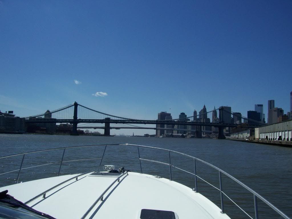
This was the type of mid-April day we had, coming down the East River towards the Manhattan Bridge. This was approx mile 115 (of 170) and we were feelin' fine!

100_3899_zps1d824c59.jpg
 
Last edited:
FYI, you don't have 200gal of usable fuel, it's about 190 on your boat.
Beautiful! Hope we get as lucky! Yeah my crew is a few friends who will be fine with whatever the weather allows. If we get a nice day, i'm going to try to maximize our distance where possible. Looks like you had a fantastic trip.
 
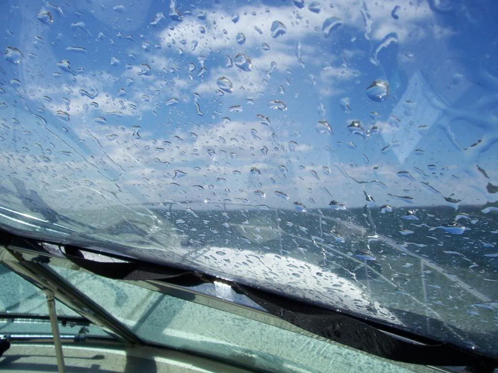
It was a very nice trip. We got VERY wet on the LI sound heading west b/c of a stiff NE wind at about 20 knots,and a wiper blade that was F'd up, but other than that, very uneventful. This was the view for about 45 miles...
100_3881_zps715eb912.jpg
 
....
@Alex: " If you see Eastern component (especially NE), only if it's mild and wasn't blowing for days,"
What's Eastern component? Sorry wasn't sure waht you mean there...I guess my question is "how do I know whether it's ok to stick my nose out into DE bay?

G

GG,

As most captains know, the wind speed and direction, and of course the seas state (wave height) are the most important info to be monitored. When you see forecast like "NE" (North/East) wind at 15-20kts, it means that the wind will be coming FROM NE direction. When studying the charts, you can clearly see that As you begin your cruise in DE Bay you're heading East bound. Generally speaking, the ocean mass is East of you and any wind coming from easterly direction (AKA Eastern component of the NE or SE wind forecast), won't be your friend. In simple terms, let's say the wind was blowing 15-20kts from ENE for the past couple days before your trip. The momentum of the seas has been building up for those days and seas will easily reach 6-8 footers. Heading out of the DE Bay (east bound) you'll be heading into the seas. As soon as you come out of the DE mouth or out of Cape May inlet and start heading NE bound hugging the shore, those seas will be your beam seas. All of the above will create VERY uncomfortable ride, which you'll want to avoid.

here's one of the sources I use:

http://marine.weather.gov/MapClick.php?lon=-74.75091&lat=38.72863#.Vr1WfPA8KrU
 
Planing a trip through the craphole known on your charts as the Delaware Bay, but known in our hearts as the Hellaware Bay, the most important thing to look at, AND the only thing you can plan for long term, is the current. With the current at your back, not only will you pick up a couple of knots, go faster and burn less fuel, you will also minimize the potential for wind-versus-current induced hell. This effect is more pronounced on the Hellaware then anywhere else I have seen, owing to the SE orientation of the Bay, the strong currents and the long fetch available to a NW wind. But planning your tip to put that current at your back is always a great place to start.

Also, there are few available "stops" between the C&D and Cape May, but it CAN be a reasonable ride. It can also suck.
 
Can I comment on something you said on the OP. You are going with 4 other buddies in a 310? I hope you make hotel reservations. That is one crowded boat for sleeping. The route the others have handled.


Sent from my iPhone using Tapatalk
 
Can I comment on something you said on the OP. You are going with 4 other buddies in a 310? I hope you make hotel reservations. That is one crowded boat for sleeping. The route the others have handled.


Sent from my iPhone using Tapatalk

Yeah, I anticipate a little discomfort there...close friends and relatives, so we'll laugh and probably cry a little at the "accommodations" but yeah i'm aware!
 
I'll throw in my 2 cents, but I have nowhere near the amount of cruising experience as these guys. We slip just north of where you keep your boat and have made several trips to the bay, but never when Dahlgren has been hot. For the record, Dahlgren is around an hour to 1 1/2 hours from Neabsco at at 25-30 mph cruising speed. Debris is a hazard in the Potomac all year, depending upon recent rainfall, but we usually always cruise in the speed range noted above with full attention on our path, unless it is just after a rainstorm. We sometimes don't go out at all after a heavy storm as there can be a ton of debris.

Solomon's Island is easily doable in your boat, but I would consider a fuel stop in Solomons kind of a slow one. By that, I mean it is a few miles off course to get fuel. Most of the Potomac from Neabsco to the bay is a reasonable depth for cruising. Therefore, you can usually transit the shortest course available. Using that scenario, Coles Point Marina is a pretty good spot to top of your tanks on the way to Annapolis. Your course will more than likely have you close to the Coles Point area, and it's a quick trip inside to get fuel there. Using that same straight line scenario, Point Lookout Marina is another quick stop fuel stop. I have fueled at Coles Point, but have not at Point Lookout. I would call both places to check their availability in April.

As mentioned previously, Point Lookout can be pretty rough depending on the current and wind direction. Last summer, we were attempting to go to St. Michael's after overnighting in Cobb Island, MD. There was a small craft advisory on the Lower Potomac, and the bay near Point Lookout. Winds were out of the N/NE at around 25 knots. We pulled out of the protected waters of Cobb Island and poked out nose into the Potomac. It wasn't bad, so we headed for the bay. Once we made the turn at Point Lookout, we encountered short interval 4-6 footers, and after a little while, we turned around and headed home. It was just too uncomfortable and slow to continue.

At other times, we have cruised around the corner with the water as smooth as glass.

Hope this helps some.
 
@mikemapva it helps a ton! I will take a gander at a route to point lookout marina...stay tuned


Sent from my iPhone using Tapatalk
 
I did part of this trip last year when i took delivery of my 320. Our trip was from Annapolis to Cape may and then cape may to Barnigate inlet. we overnighted at South Jersey Marina... (great people terrible dock) The entire trip was great! I will say be AWARE once in the Cape May Canal. Once inside it can get VERY shallow in a hurry on the port side of the channel. Im referring to the area where the ferry boat docks... when the boat docks during business hours it stays in gear to keep pressure agents the dock this causes a ton of wash to build up on the opposite side of the channel. I didnt know this til a later trip through but i was in the middle and saw a hump at high tide... better safe then sorry and stay starboard... (close to the ferry dock)

Hope this helps safe travels! enjoy...
 

Forum statistics

Threads
112,873
Messages
1,420,838
Members
60,871
Latest member
cbrcassio
Back
Top