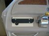
I bought and put into service a Garmin 3210 this summer. I have not found a permanent mounting location that I like (OK, I'm procrastinating), so presently it is just attached to a wood base that sits in the port side helm area. Though I have yet done a permanent mount, everything seems easy so far regarding the installation.
I did not buy any accessories with this unit, just the basic chartplotter which includes the remote antenna. I had two primary reasons for buying a chartplotter. First, I had already hit bottom in the Columbia once with the 270, causing about $1500 damage So I wanted real time display of any near hazards. Secondly, I wanted to have a chartplotter aboard before my next trip to the San Juan Islands.
I chose this unit for one reason over the other brands, and that reason is the included charts themselves. I compared the Garmin with the Raymarine and others for known underwater topology in my area, and the Garmin was the best. It was the only one that would have shown me the obstacle I hit. Also I am just 30 miles from where the Snake runs into the Columbia, and would like to spend some time on the Snake River. The Garmin was the only one with the Snake River included in the database.
In the San Juan Islands, I preferred the charts displayed by the Raymarine model, I think I was comparing to a C70. I thought the C70 displayed more useful information in Victoria Harbor and its entrance for example.
When I operatied both units side by side in the store in Portland, I preferred the operation of the Raymarine unit. The response to the cursor seemed better, and the menu seemed more intuitive. I still do struggle with the Garmin menu at times, but sitting here in front of the computer I can't recall the exact problems I have.
I really preferred the Raymarine unit for its nice operation and nice looking charts. But my first reason for buying was to keep me out of the rocks in the Columbia. That really dictated the Garmin unit.
Quality of the construction seems quite good to me. But the price of the additional parts to add other functions is not competitive with other units, IMHO. This also tended to push me towards other vendors, but I had to keep coming back to the primary reason for buying the unit, the quality of the charts in my area. For other areas, I don't know if the Garmin has an advantage or not.
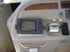
I find the viewability of my unit to be good. It is fine in the daytime, regardless of lighting. It also dims very well for night time use. I chose the 3210 model over the 3206 primary because my vision is not as good as it used to be, and the larger display is easier for me to see. I think the 3210 and the 3206 both have the same number of pixels, just one is a 10 inch display, the other a 6 inch display.
After buying the unit, I went back to where I had struck bottom. I have looked very closely more than once for visual clues that would have told me the water depth changes from 30 ft to 2 ft in the length of my boat. I have found none. And whle the location is approximately marked on a river chart. When at the obstruction, it is hard to believe that it is where it is unless the water level is high enough you can float over it and reach down and touch it with a boat hook.
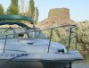
The photo below shows of Hat Rock in the background. It is above the water, obviously. But similar formatons are common in the area above water, and I tihink the one I am now trying to avoid underwater is similar.
I did not buy any accessories with this unit, just the basic chartplotter which includes the remote antenna. I had two primary reasons for buying a chartplotter. First, I had already hit bottom in the Columbia once with the 270, causing about $1500 damage So I wanted real time display of any near hazards. Secondly, I wanted to have a chartplotter aboard before my next trip to the San Juan Islands.
I chose this unit for one reason over the other brands, and that reason is the included charts themselves. I compared the Garmin with the Raymarine and others for known underwater topology in my area, and the Garmin was the best. It was the only one that would have shown me the obstacle I hit. Also I am just 30 miles from where the Snake runs into the Columbia, and would like to spend some time on the Snake River. The Garmin was the only one with the Snake River included in the database.
In the San Juan Islands, I preferred the charts displayed by the Raymarine model, I think I was comparing to a C70. I thought the C70 displayed more useful information in Victoria Harbor and its entrance for example.
When I operatied both units side by side in the store in Portland, I preferred the operation of the Raymarine unit. The response to the cursor seemed better, and the menu seemed more intuitive. I still do struggle with the Garmin menu at times, but sitting here in front of the computer I can't recall the exact problems I have.
I really preferred the Raymarine unit for its nice operation and nice looking charts. But my first reason for buying was to keep me out of the rocks in the Columbia. That really dictated the Garmin unit.
Quality of the construction seems quite good to me. But the price of the additional parts to add other functions is not competitive with other units, IMHO. This also tended to push me towards other vendors, but I had to keep coming back to the primary reason for buying the unit, the quality of the charts in my area. For other areas, I don't know if the Garmin has an advantage or not.
I find the viewability of my unit to be good. It is fine in the daytime, regardless of lighting. It also dims very well for night time use. I chose the 3210 model over the 3206 primary because my vision is not as good as it used to be, and the larger display is easier for me to see. I think the 3210 and the 3206 both have the same number of pixels, just one is a 10 inch display, the other a 6 inch display.
After buying the unit, I went back to where I had struck bottom. I have looked very closely more than once for visual clues that would have told me the water depth changes from 30 ft to 2 ft in the length of my boat. I have found none. And whle the location is approximately marked on a river chart. When at the obstruction, it is hard to believe that it is where it is unless the water level is high enough you can float over it and reach down and touch it with a boat hook.
The photo below shows of Hat Rock in the background. It is above the water, obviously. But similar formatons are common in the area above water, and I tihink the one I am now trying to avoid underwater is similar.